Tara Roberts, a writer for Stanford University, takes a behind-the-scenes look at the development of a new modeling approach from Stanford University and the University of Florida, which is expected to help planners simulate future flood risks and prepare urban areas for the increasing number of extreme hydrological weather events. (This article has been adapted from a story originally published by Stanford University.)
Plans for flood mitigation along urban rivers often benefit some neighborhoods more than others. Researchers and collaborators in a densely populated California floodplain developed a way to help planners see how infrastructure designs, sea level rise and severe storms fueled by climate change will affect flood risk at the local level.
Rising seas and extreme storms fueled by climate change are combining to generate more frequent and severe floods in cities along rivers and coasts, and aging infrastructure is poorly equipped for the new reality. But when governments and planners try to prepare communities for worsening flood risks by improving infrastructure, the benefits are often unfairly distributed.
A new modeling approach from Stanford University and University of Florida researchers offers a solution: an easy way for planners to simulate future flood risks at the neighborhood level under conditions expected to become commonplace with climate change, such as extreme rainstorms that coincide with high tides elevated by rising sea levels.
The approach, described May 28 in Environmental Research Letters, reveals places where elevated risk is invisible with conventional modeling methods designed to assess future risks based on data from a single past flood event. “Asking these models to quantify the distribution of risk along a river for different climate scenarios is kind of like asking a microwave to cook a sophisticated souffle. It’s just not going to go well,” said senior study author Jenny Suckale, an associate professor of geophysics at the Stanford Doerr School of Sustainability. “We don’t know how the risk is distributed, and we don’t look at who benefits and to which degree.”
Helping other flood-prone communities
The new approach to modeling flood risk can help city and regional planners create better flood risk assessments and avoid creating new inequities, Suckale said. The algorithm is publicly available for other researchers to adapt to their location.
A history of destructive floods
The new study came about through collaboration with regional planners and residents in bayside cities including East Palo Alto, which faces rising flood risks from the San Francisco Bay and from an urban river that snakes along its southeastern border.
The river, known as the San Francisquito Creek, meanders from the foothills above Stanford’s campus down through engineered channels to the bay – its historic floodplains long ago developed into densely populated cities. “We live around it, we drive around it, we drive over it on the bridges,” said lead study author Katy Serafin, a former postdoctoral scholar in Suckale’s research group.
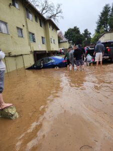
The river has a history of destructive floods. The biggest one, in 1998, inundated 1,700 properties, caused more than US$40m in damages, and led to the creation of a regional agency tasked with mitigating future flood risk.
Nearly 20 years after that historic flood, Suckale started thinking about how science could inform future flood mitigation efforts around urban rivers like the San Francisquito when she was teaching a course in East Palo Alto focused on equity, resilience and sustainability in urban areas. Designated as a Cardinal Course for its strong public service component, the course was offered most recently under the title Shaping the Future of the Bay Area.
Around the time Suckale started teaching the course, the regional agency – known as the San Francisquito Creek Joint Powers Authority – had developed plans to redesign a bridge to enable more water to flow underneath it and prevent flooding in creekside cities. But East Palo Alto city officials told Suckale and her students that they worried the plan could worsen flood risks in some neighborhoods downstream of the bridge.
Suckale realized that if the students and scientists could determine how the proposed design would affect the distribution of flood risks along the creek, while collaborating with the agency to understand its constraints, then their findings could guide decisions about how to protect all neighborhoods. “It’s actionable science, not just science for science’s sake,” she said.
Science that leads to action
The Joint Powers Authority had developed the plan using a flood risk model commonly used by hydrologists around the world. The agency had considered the concerns raised by East Palo Alto city staff about downstream flood risks, but found that the standard model couldn’t substantiate them.
“We wanted to model a wider range of factors that will contribute to flood risk over the next few decades as our climate changes,” said Serafin, who served as a mentor to students in the Cardinal Course and is now an assistant professor at the University of Florida.
Serafin created an algorithm to simulate millions of combinations of flood factors, including sea level rise and more frequent episodes of extreme rainfall – a consequence of global warming that is already being felt in East Palo Alto and across California.
Serafin and Suckale incorporated their new algorithm into the widely used model to compute the statistical likelihood that the San Francisquito Creek would flood at different locations along the river. They then overlaid these results with aggregated household income and demographic data and a federal index of social vulnerability.
They found that the redesign of the upstream bridge would provide adequate protection against a repeat of the 1998 flood, which was once considered a 75-year flood event. But the modeling revealed that the planned design would leave hundreds of low-income households in East Palo Alto exposed to increased flood risk as climate change makes once-rare severe weather and flood events more common.
A beneficial collaboration
When the scientists shared their findings with the city of East Palo Alto, the Joint Powers Authority, and other community collaborators in conversations over several years, they emphasized that the conventional model wasn’t wrong – it just wasn’t designed to answer questions about equity.
The results provided scientific evidence to guide the Joint Powers Authority’s infrastructure plans, which expanded to include the construction of a permanent floodwall beside the creek in East Palo Alto. The agency also adopted a plan to build up the creek’s bank in a particularly low area to better protect neighboring homes and streets.
Ruben Abrica, East Palo Alto’s elected representative to the Joint Powers Authority board, said researchers, planners, city staff and policymakers have a responsibility to work together to “carry out projects that don’t put some people in more danger than others”.
The results of the Stanford research demonstrated how seemingly neutral models that ignore equity can lead to uneven distributions of risks and benefits. “Scientists have to become more aware of the impact of the research, because the people who read the research or the people who then do the planning are relying on them,” he said.
Serafin and Suckale said their work with San Francisquito Creek demonstrates the importance of mutual respect and trust among researchers and communities positioned not as subjects of study, but as active contributors to the creation of knowledge. “Our community collaborators made sure we, as scientists, understood the realities of these different communities,” Suckale said. “We’re not training them to be hydrological modelers. We are working with them to make sure that the decisions they’re making are transparent and fair to the different communities involved.”
For more of the top insights into the development of impact-based forecasting, read Meteorological Technology International’s exclusive feature, “How are impact-based forecasts developing to minimize the human and economic costs of weather hazards?” here.