


Close Menu
Meteorological Technology International
  • News
    • A-E
      • Agriculture
      • Automated Weather Stations
      • Aviation
      • Climate Measurement
      • Data
      • Developing Countries
      • Digital Applications
      • Early Warning Systems
      • Extreme Weather
    • G-P
      • Hydrology
      • Lidar
      • Lightning Detection
      • New Appointments
      • Nowcasting
      • Numerical Weather Prediction
      • Polar Weather
    • R-S
      • Radar
      • Rainfall
      • Remote Sensing
      • Renewable Energy
      • Satellites
      • Solar
      • Space Weather
      • Supercomputers
    • T-Z
      • Training
      • Transport
      • Weather Instruments
      • Wind
      • World Meteorological Organization
      • Meteorological Technology World Expo
  • Features
  • Online Magazines
    • January 2026
    • April 2025
    • January 2025
    • September 2024
    • April 2024
    • Archive Issues
    • Subscribe Free!
  • Opinion
  • Videos
  • Supplier Spotlight
  • Expo
LinkedIn X (Twitter) Facebook
  • Sign-up for Free Weekly E-Newsletter
  • Meet the Editors
  • Contact Us
  • Media Pack
LinkedIn Facebook
Subscribe
Meteorological Technology International
  • News
      • Agriculture
      • Automated Weather Stations
      • Aviation
      • Climate Measurement
      • Data
      • Developing Countries
      • Digital Applications
      • Early Warning Systems
      • Extreme Weather
      • Hydrology
      • Lidar
      • Lightning Detection
      • New Appointments
      • Nowcasting
      • Numerical Weather Prediction
      • Polar Weather
      • Radar
      • Rainfall
      • Remote Sensing
      • Renewable Energy
      • Satellites
      • Solar
      • Space Weather
      • Supercomputers
      • Training
      • Transport
      • Weather Instruments
      • Wind
      • World Meteorological Organization
      • Meteorological Technology World Expo
  • Features
  • Online Magazines
    1. April 2026
    2. January 2026
    3. September 2025
    4. April 2025
    5. January 2025
    6. September 2024
    7. April 2024
    8. January 2024
    9. Archive Issues
    10. Subscribe Free!
    Featured
    May 5, 2026

    In this Issue – April 2026

    By Web TeamMay 5, 2026
    Recent

    In this Issue – April 2026

    May 5, 2026

    In this Issue – January 2026

    November 27, 2025

    In this Issue – September 2025

    August 11, 2025
  • Opinion
  • Videos
  • Supplier Spotlight
  • Expo
Facebook LinkedIn
Subscribe
Meteorological Technology International
Climate Measurement

Colombia deploys ocean sensors to improve hurricane preparedness

Dan SymondsBy Dan SymondsJuly 12, 20223 Mins Read
Share LinkedIn Facebook Twitter Email
Photo: CEMarin.-e1657645181914
Share
LinkedIn Facebook Twitter Email

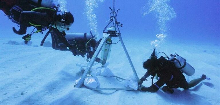
Government-funded researchers from Colombia have been using wave and ocean current data measured by sensors from Nortek, a Norwegian acoustic Doppler instrumentation specialist, to improve hurricane prediction.

Colombia’s Caribbean islands were devastated by hurricanes Eta and Iota within a two-week period in November 2020. With a total of 14 hurricanes, 2020 was the most active Atlantic hurricane season to date.

The experience of Eta and Iota prompted the authorities on the Archipelago of San Andrés, Providencia and Santa Catalina to request help from the Universidad Nacional de Colombia and the regional environmental protection agency, CORALINA, to develop tools to plan and prepare for future events, including computer modeling to better predict hurricane risk.

Dr Andrés Fernando Osorio Arias, professor at the Universidad Nacional de Colombia and executive director of the Center of Excellence in Marine Sciences (CEMarin), said, “We use these models to create reconstructions of hurricanes that have occurred in the past, and also to predict scenarios that have not yet occurred – synthetic scenarios of hurricanes.”

While such models are generally robust, their accuracy is improved by comparison with data measured from the field. This is particularly important as biophysical features such as coral reefs, mangroves and seagrasses can influence sea conditions around islands.

“It’s important to collect information from the field and try to reproduce conditions on a laboratory scale because, in the laboratory, you have more control of the different factors,” he added. “With field and laboratory data, you can develop new equations, new parameters and new physical understanding of physical processes to improve the models.”

The scientists gather real-world data on current and wave direction using two AWAC subsea sensors made by Nortek. These record the motion of the water using calculations based on the Doppler effect. The sensors emit sound waves, then measure the echoes that return after bouncing off particles suspended in the water. As waves travel horizontally, these move with the water in a circular, or orbital, motion. This provides insight into how the height and direction of waves varies according to weather conditions.

Cristobal Molina, senior sales engineer for Latin America and Mediterranean, said, “The waves on the surface are a combination of many waves, which have different directions, periods and heights. The AWAC acoustic sensor takes measurements over a long period, allowing us to discriminate between the different waves.”

Having validated the model with the real-world data from Eta and Iota, the researchers can now confidently create synthetic hurricane scenarios to identify the areas of the islands that are most vulnerable to flooding. As a result, the authorities can take action to protect vulnerable communities, such as planting seagrass in strategic locations.

Previous ArticleCIRES unveils plans to launch environmental data science and diversity initiative
Next Article North Atlantic expedition to investigate impact of ocean changes on UK weather

Read Similar Stories

Weather Instruments

R.M. Young Company reengineers SNOdar snow-depth sensor

May 21, 20262 Mins Read
Climate Measurement

Cloud measurement campaign targets improved climate model accuracy

May 20, 20263 Mins Read
Videos

VIDEO: Meteosat-12 imagery over Europe and Africa made available via YouTube streams

May 19, 20262 Mins Read
Latest News

R.M. Young Company reengineers SNOdar snow-depth sensor

May 21, 2026

SMILE mission launches to study Earth’s magnetic shield and space weather

May 20, 2026

Cloud measurement campaign targets improved climate model accuracy

May 20, 2026

Receive breaking stories and features in your inbox each week, for free


Enter your email address:


Supplier Spotlights
  • Senseca
Getting in Touch
  • Contact Us / Advertise
  • Meet the Editors
  • Media Pack
  • Free Weekly E-Newsletter
Our Social Channels
  • Facebook
  • LinkedIn
© 2026 UKi Media & Events a division of UKIP Media & Events Ltd
  • Cookie Policy
  • Privacy Policy
  • Terms and Conditions
  • Notice and Takedown Policy

Type above and press Enter to search. Press Esc to cancel.