Close Menu
Meteorological Technology International
  • News
    • A-E
      • Agriculture
      • Automated Weather Stations
      • Aviation
      • Climate Measurement
      • Data
      • Developing Countries
      • Digital Applications
      • Early Warning Systems
      • Extreme Weather
    • G-P
      • Hydrology
      • Lidar
      • Lightning Detection
      • New Appointments
      • Nowcasting
      • Numerical Weather Prediction
      • Polar Weather
    • R-S
      • Radar
      • Rainfall
      • Remote Sensing
      • Renewable Energy
      • Satellites
      • Solar
      • Space Weather
      • Supercomputers
    • T-Z
      • Training
      • Transport
      • Weather Instruments
      • Wind
      • World Meteorological Organization
      • Meteorological Technology World Expo
  • Features
  • Online Magazines
    • January 2026
    • April 2025
    • January 2025
    • September 2024
    • April 2024
    • Archive Issues
    • Subscribe Free!
  • Opinion
  • Videos
  • Supplier Spotlight
  • Expo
LinkedIn X (Twitter) Facebook
  • Sign-up for Free Weekly E-Newsletter
  • Meet the Editors
  • Contact Us
  • Media Pack
LinkedIn Facebook
Subscribe
Meteorological Technology International
  • News
      • Agriculture
      • Automated Weather Stations
      • Aviation
      • Climate Measurement
      • Data
      • Developing Countries
      • Digital Applications
      • Early Warning Systems
      • Extreme Weather
      • Hydrology
      • Lidar
      • Lightning Detection
      • New Appointments
      • Nowcasting
      • Numerical Weather Prediction
      • Polar Weather
      • Radar
      • Rainfall
      • Remote Sensing
      • Renewable Energy
      • Satellites
      • Solar
      • Space Weather
      • Supercomputers
      • Training
      • Transport
      • Weather Instruments
      • Wind
      • World Meteorological Organization
      • Meteorological Technology World Expo
  • Features
  • Online Magazines
    1. January 2026
    2. September 2025
    3. April 2025
    4. January 2025
    5. September 2024
    6. April 2024
    7. January 2024
    8. September 2023
    9. April 2023
    10. Archive Issues
    11. Subscribe Free!
    Featured
    November 27, 2025

    In this Issue – January 2026

    By Hazel KingNovember 27, 2025
    Recent

    In this Issue – January 2026

    November 27, 2025

    In this Issue – September 2025

    August 11, 2025

    In this Issue – April 2025

    April 15, 2025
  • Opinion
  • Videos
  • Supplier Spotlight
  • Expo
Facebook LinkedIn
Subscribe
Meteorological Technology International
Extreme Weather

Saildrone launches second campaign to monitor US hurricane season using drones

Dan SymondsBy Dan SymondsAugust 4, 20223 Mins Read
Share LinkedIn Facebook Twitter Email
Credit - Saildrone
Share
LinkedIn Facebook Twitter Email

Marine drone developer Saildrone has partnered with NOAA’s Office of Oceanic and Atmospheric Research to launch its second hurricane mission, with seven uncrewed surface vehicles (USVs) sent to monitor how hurricanes grow and intensify in the Atlantic Ocean and the Gulf of Mexico.

During last year’s hurricane season in the Atlantic Ocean, one USV sailed through the eyewall of Category 4 Hurricane Sam, sending back live video footage from inside the eye of the storm.

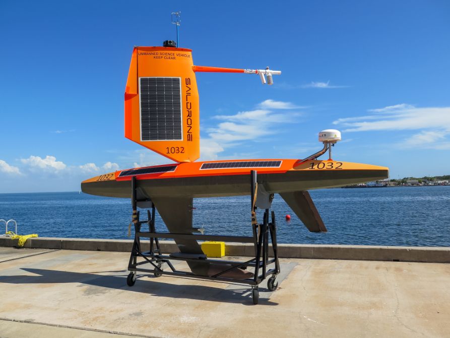
This year, Saildrone will collect critical data from both the Atlantic Ocean and the Gulf of Mexico expanding the potential impact of the mission. This week, one of the USVs bound for an operation area in the eastern Gulf of Mexico, SD 1032, was deployed from Saildrone’s Ocean Mapping Headquarters in St Petersburg, Florida, and another was deployed from Port Aransas, Texas, for the western Gulf.

Richard Jenkins, CEO, Saildrone, said, “We are excited to expand this effort to collect vital data in both the Atlantic and the Gulf of Mexico. We opened our Florida office earlier this year to support exactly this kind of mission, as well as our goal of mapping the entire sea floor around Florida. Combining in situ ocean data with a better understanding of the ocean floor, will help us predict both storm intensity and storm surges, keeping our coastal communities safer from these destructive events.”

NOAA predicts an above-average 2022 hurricane season, with up to 21 named storms and three to six major hurricanes. The Atlantic Hurricane mission aims to improve understanding and predictability of tropical cyclone intensity changes and advance knowledge of the ocean-atmosphere interactions that fuel them. The saildrones will provide in situ data to NOAA’s Pacific Marine Environmental Laboratory (PMEL) and Atlantic Oceanographic and Meteorological Laboratory (AOML).

The seven saildrones are a part of a larger NOAA endeavor to understand hurricane intensification. They will join an array of underwater gliders, surface drifters, profiling floats and aerial assets to collectively gain deeper insight into the development of these storms. AOML scientists on board NOAA’s P-3 and Gulfstream IV Hurricane Hunter aircraft will help gather weather observations from hurricanes, and the P-3 will also launch small uncrewed aerial systems to sample the atmosphere above.

Captain Philip Hall, director of NOAA’s Uncrewed Systems Operations Center, said, “Uncrewed marine and aircraft systems have the potential to transform how NOAA meets its mission to better understand the environment. These exciting emerging technologies provide NOAA with another valuable tool that can collect data in places we can’t get to with other observing systems.”

The saildrones will transmit meteorological and oceanographic in situ data in real time including air temperature and relative humidity, barometric pressure, wind speed and direction, water temperature and salinity, sea surface temperature, and wave height and duration.

NOAA Research will use the data collected by the saildrones to improve hurricane forecast models. The data will also be archived by NOAA’s National Environmental Satellite, Data and Information Service (NESDIS) and sent by NOAA in near real time to the World Meteorological Organization’s (WMO) Global Telecommunication System (GTS) where it is available for the world’s major forecast centers.

Credit – Saildrone
Previous ArticleUCAR unveiled as new base for Center for Ocean Leadership
Next Article US high tide flooding breaks records in several locations, NOAA reports

Read Similar Stories

Digital Applications

ForecastWatch expands with launch of new independent platform for weather forecast verification

April 28, 20262 Mins Read
Climate Measurement

European climate report highlights record heat, glacier loss and rising extremes

April 27, 20263 Mins Read
Agriculture

Extreme heat posing significant risks to ecosystems and agriculture, FAO-WMO report warns

April 22, 20263 Mins Read
Latest News

ForecastWatch expands with launch of new independent platform for weather forecast verification

April 28, 2026

European climate report highlights record heat, glacier loss and rising extremes

April 27, 2026

WMO signals increasing likelihood of El Niño developing in 2026

April 24, 2026

Receive breaking stories and features in your inbox each week, for free


Enter your email address:


Supplier Spotlights
  • GAMIC GmbH
Getting in Touch
  • Contact Us / Advertise
  • Meet the Editors
  • Media Pack
  • Free Weekly E-Newsletter
Our Social Channels
  • Facebook
  • LinkedIn
© 2026 UKi Media & Events a division of UKIP Media & Events Ltd
  • Cookie Policy
  • Privacy Policy
  • Terms and Conditions
  • Notice and Takedown Policy

Type above and press Enter to search. Press Esc to cancel.