

Close Menu
Meteorological Technology International
  • News
    • A-E
      • Agriculture
      • Artificial Intelligence
      • Automated Weather Stations
      • Aviation
      • Climate Measurement
      • Data
      • Developing Countries
      • Digital Applications
      • Early Warning Systems
      • Extreme Weather
    • G-P
      • Hydrology
      • Lidar
      • Lightning Detection
      • New Appointments
      • Nowcasting
      • Numerical Weather Prediction
      • Polar Weather
    • R-S
      • Radar
      • Rainfall
      • Remote Sensing
      • Renewable Energy
      • Satellites
      • Solar
      • Space Weather
      • Supercomputers
    • T-Z
      • Training
      • Transport
      • Weather Instruments
      • Wind
      • World Meteorological Organization
      • Meteorological Technology World Expo
  • Features
  • Online Magazines
    • September 2026
    • January 2026
    • April 2025
    • January 2025
    • September 2024
    • April 2024
    • Archive Issues
    • Subscribe Free!
  • Opinion
  • Videos
  • Supplier Spotlight
  • Expo
LinkedIn X (Twitter) Facebook
  • Sign-up for Free Weekly E-Newsletter
  • Meet the Editors
  • Contact Us
  • Media Pack
LinkedIn Facebook
Subscribe
Meteorological Technology International
  • News
      • Agriculture
      • Artificial Intelligence
      • Automated Weather Stations
      • Aviation
      • Climate Measurement
      • Data
      • Developing Countries
      • Digital Applications
      • Early Warning Systems
      • Extreme Weather
      • Hydrology
      • Lidar
      • Lightning Detection
      • New Appointments
      • Nowcasting
      • Numerical Weather Prediction
      • Polar Weather
      • Radar
      • Rainfall
      • Remote Sensing
      • Renewable Energy
      • Satellites
      • Solar
      • Space Weather
      • Supercomputers
      • Training
      • Transport
      • Weather Instruments
      • Wind
      • World Meteorological Organization
      • Meteorological Technology World Expo
  • Features
  • Online Magazines
    1. September 2026
    2. April 2026
    3. January 2026
    4. September 2025
    5. April 2025
    6. January 2025
    7. September 2024
    8. April 2024
    9. January 2024
    10. Archive Issues
    11. Subscribe Free!
    Featured
    August 4, 2026

    In this Issue – September 2026

    By Web TeamAugust 4, 2026
    Recent

    In this Issue – September 2026

    August 4, 2026

    In this Issue – April 2026

    May 5, 2026

    In this Issue – January 2026

    November 27, 2025
  • Opinion
  • Videos
  • Supplier Spotlight
  • Expo
Facebook LinkedIn
Subscribe
Meteorological Technology International
Data

Satellite analysis shows last year’s Amazon wildfires similar to those of previous years

Paul WillisBy Paul WillisMarch 19, 20202 Mins Read
Share LinkedIn Facebook Twitter Email
Share
LinkedIn Facebook Twitter Email

The fires that ravaged the Amazon region last year provoked worldwide concern. Yet in spite of widespread coverage in the media and intense international scrutiny, a new analysis reveals that the wildfires were not much worse than previous years.

The detailed analysis used satellite data from the European Space Agency’s (ESA) Climate Change Initiative (CCI) to measure the extent of the 2019 fires.

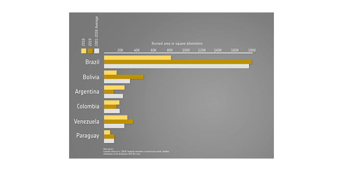
The analysis, published recently in the journal Remote Sensing, found that while there was a small increase compared to 2018, the number of fires was not much different to the annual average detected over the past 18 years.

According to the paper, areas destroyed by wildfires across the whole of South America rose by around 70% in 2019 compared with the same period of 2018. However the 2019 rate was still only slightly higher than the yearly average over the past 17 years.

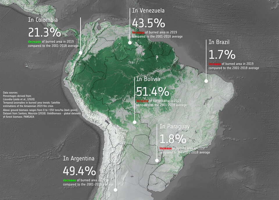
Despite being the focus of international condemnation for its perceived inaction, Brazil saw only a 1.7% increase of burned area in 2019 compared to the long-term average. Bolivia, by contrast, saw a 51.4% increase compared to the yearly average.

The burned area estimates used in the study came from ESA’s Fire CCI project, which produces long-term datasets of burned area information from satellites.

Emilio Chuvieco, science leader of the Fire CCI project, said, “Studies such as these are important to quantify and monitor fire activities in places such as the Amazon. However, they indicate the importance of long-term data series and studies using higher resolution sensors, such as the Copernicus Sentinel-2 multispectral instrument, to detect fires.”
Previous ArticleScientists create system to forecast global warming in world’s lakes
Next Article Supercomputing center closure one of many US weather agency coronavirus shutdowns

Read Similar Stories

Features

EXCLUSIVE INTERVIEW: Maarten van Aalst, director-general, KNMI

September 2, 20265 Mins Read
Satellites

MTG-I2 launches, completing Europe’s three-satellite weather constellation

September 1, 20262 Mins Read
Data

EUMETSAT renews and expands Spire Global weather data contract to €4 million

August 26, 20262 Mins Read
Latest News

WMO forecasts very strong El Niño, with severe weather risks increasing into 2027

September 3, 2026

One month to go until Meteorological Technology World Expo returns to Amsterdam

September 3, 2026

EXCLUSIVE INTERVIEW: Maarten van Aalst, director-general, KNMI

September 2, 2026

Receive breaking stories and features in your inbox each week, for free


Enter your email address:


Supplier Spotlights
  • ZX Lidars
Getting in Touch
  • Contact Us / Advertise
  • Meet the Editors
  • Media Pack
  • Free Weekly E-Newsletter
Our Social Channels
  • Facebook
  • LinkedIn
© 2026 UKi Media & Events a division of UKIP Media & Events Ltd
  • Cookie Policy
  • Privacy Policy
  • Terms and Conditions
  • Notice and Takedown Policy

Type above and press Enter to search. Press Esc to cancel.