

Close Menu
Meteorological Technology International
  • News
    • A-E
      • Agriculture
      • Artificial Intelligence
      • Automated Weather Stations
      • Aviation
      • Climate Measurement
      • Data
      • Developing Countries
      • Digital Applications
      • Early Warning Systems
      • Extreme Weather
    • G-P
      • Hydrology
      • Lidar
      • Lightning Detection
      • New Appointments
      • Nowcasting
      • Numerical Weather Prediction
      • Polar Weather
    • R-S
      • Radar
      • Rainfall
      • Remote Sensing
      • Renewable Energy
      • Satellites
      • Solar
      • Space Weather
      • Supercomputers
    • T-Z
      • Training
      • Transport
      • Weather Instruments
      • Wind
      • World Meteorological Organization
      • Meteorological Technology World Expo
  • Features
  • Online Magazines
    • September 2026
    • January 2026
    • April 2025
    • January 2025
    • September 2024
    • April 2024
    • Archive Issues
    • Subscribe Free!
  • Opinion
  • Videos
  • Supplier Spotlight
  • Expo
LinkedIn X (Twitter) Facebook
  • Sign-up for Free Weekly E-Newsletter
  • Meet the Editors
  • Contact Us
  • Media Pack
LinkedIn Facebook
Subscribe
Meteorological Technology International
  • News
      • Agriculture
      • Artificial Intelligence
      • Automated Weather Stations
      • Aviation
      • Climate Measurement
      • Data
      • Developing Countries
      • Digital Applications
      • Early Warning Systems
      • Extreme Weather
      • Hydrology
      • Lidar
      • Lightning Detection
      • New Appointments
      • Nowcasting
      • Numerical Weather Prediction
      • Polar Weather
      • Radar
      • Rainfall
      • Remote Sensing
      • Renewable Energy
      • Satellites
      • Solar
      • Space Weather
      • Supercomputers
      • Training
      • Transport
      • Weather Instruments
      • Wind
      • World Meteorological Organization
      • Meteorological Technology World Expo
  • Features
  • Online Magazines
    1. September 2026
    2. April 2026
    3. January 2026
    4. September 2025
    5. April 2025
    6. January 2025
    7. September 2024
    8. April 2024
    9. January 2024
    10. Archive Issues
    11. Subscribe Free!
    Featured
    August 4, 2026

    In this Issue – September 2026

    By Web TeamAugust 4, 2026
    Recent

    In this Issue – September 2026

    August 4, 2026

    In this Issue – April 2026

    May 5, 2026

    In this Issue – January 2026

    November 27, 2025
  • Opinion
  • Videos
  • Supplier Spotlight
  • Expo
Facebook LinkedIn
Subscribe
Meteorological Technology International
Data

AI to predict wildfires

James MuirBy James MuirMay 22, 20202 Mins Read
Share LinkedIn Facebook Twitter Email
Wildfires
Share
LinkedIn Facebook Twitter Email

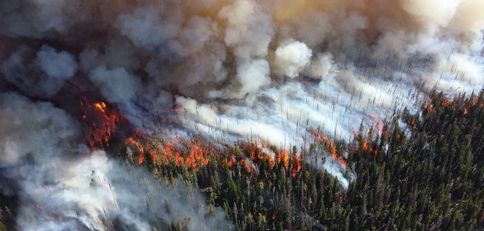
Experts from Stanford University’s School of Earth, Energy and Environmental Sciences in the US are using artificial intelligence and satellite data to predict wildfires across their western states.

The team, who specialize in hydrology, remote sensing and environmental engineering, have developed a deep-learning model to map fuel moisture levels across states from Colorado, Montana, Texas and Wyoming to the Pacific coast.

The model, which is said to require further testing, looks for forest dryness unfolding pixel by pixel, revealing areas that are at greatest risk for catching fire. Indeed, lead author Krishna Rao, a PhD student in the Earth system science, says the system uses a recurrent neural network, an artificial intelligence system that learns to recognize patterns in vast mountains of data. Scientists train the model using field data from the National Fuel Moisture Database, then ask it to estimate fuel moisture from two types of measurements collected by spaceborne sensors. One such move involves measuring visible light bouncing off the Earth and the other is synthetic aperture radar, which measures the return of microwave radar signals.

Alexandra Konings, an ecohydrologist at Stanford University, said, “One of our big breakthroughs was to look at a newer set of satellites that are using much longer wavelengths, which allows the observations to be sensitive to water much deeper into the forest canopy and be directly representative of the fuel moisture content.”

Previous ArticleEarly warning systems must be a priority
Next Article NOAA predicts a busy 2020 Atlantic hurricane season

Read Similar Stories

Satellites

MTG-I2 launches, completing Europe’s three-satellite weather constellation

September 1, 20262 Mins Read
Data

EUMETSAT renews and expands Spire Global weather data contract to €4 million

August 26, 20262 Mins Read
Radar

Bureau of Meteorology’s radar technology restores flood monitoring gauge in Cairns

August 18, 20262 Mins Read
Latest News

WMO forecasts very strong El Niño, with severe weather risks increasing into 2027

September 3, 2026

One month to go until Meteorological Technology World Expo returns to Amsterdam

September 3, 2026

EXCLUSIVE INTERVIEW: Maarten van Aalst, director-general, KNMI

September 2, 2026

Receive breaking stories and features in your inbox each week, for free


Enter your email address:


Supplier Spotlights
  • IACIT
Getting in Touch
  • Contact Us / Advertise
  • Meet the Editors
  • Media Pack
  • Free Weekly E-Newsletter
Our Social Channels
  • Facebook
  • LinkedIn
© 2026 UKi Media & Events a division of UKIP Media & Events Ltd
  • Cookie Policy
  • Privacy Policy
  • Terms and Conditions
  • Notice and Takedown Policy

Type above and press Enter to search. Press Esc to cancel.