

Close Menu
Meteorological Technology International
  • News
    • A-E
      • Agriculture
      • Automated Weather Stations
      • Aviation
      • Climate Measurement
      • Data
      • Developing Countries
      • Digital Applications
      • Early Warning Systems
      • Extreme Weather
    • G-P
      • Hydrology
      • Lidar
      • Lightning Detection
      • New Appointments
      • Nowcasting
      • Numerical Weather Prediction
      • Polar Weather
    • R-S
      • Radar
      • Rainfall
      • Remote Sensing
      • Renewable Energy
      • Satellites
      • Solar
      • Space Weather
      • Supercomputers
    • T-Z
      • Training
      • Transport
      • Weather Instruments
      • Wind
      • World Meteorological Organization
      • Meteorological Technology World Expo
  • Features
  • Online Magazines
    • January 2026
    • April 2025
    • January 2025
    • September 2024
    • April 2024
    • Archive Issues
    • Subscribe Free!
  • Opinion
  • Videos
  • Supplier Spotlight
  • Expo
LinkedIn X (Twitter) Facebook
  • Sign-up for Free Weekly E-Newsletter
  • Meet the Editors
  • Contact Us
  • Media Pack
LinkedIn Facebook
Subscribe
Meteorological Technology International
  • News
      • Agriculture
      • Automated Weather Stations
      • Aviation
      • Climate Measurement
      • Data
      • Developing Countries
      • Digital Applications
      • Early Warning Systems
      • Extreme Weather
      • Hydrology
      • Lidar
      • Lightning Detection
      • New Appointments
      • Nowcasting
      • Numerical Weather Prediction
      • Polar Weather
      • Radar
      • Rainfall
      • Remote Sensing
      • Renewable Energy
      • Satellites
      • Solar
      • Space Weather
      • Supercomputers
      • Training
      • Transport
      • Weather Instruments
      • Wind
      • World Meteorological Organization
      • Meteorological Technology World Expo
  • Features
  • Online Magazines
    1. April 2026
    2. January 2026
    3. September 2025
    4. April 2025
    5. January 2025
    6. September 2024
    7. April 2024
    8. January 2024
    9. Archive Issues
    10. Subscribe Free!
    Featured
    May 5, 2026

    In this Issue – April 2026

    By Web TeamMay 5, 2026
    Recent

    In this Issue – April 2026

    May 5, 2026

    In this Issue – January 2026

    November 27, 2025

    In this Issue – September 2025

    August 11, 2025
  • Opinion
  • Videos
  • Supplier Spotlight
  • Expo
Facebook LinkedIn
Subscribe
Meteorological Technology International
Extreme Weather

Stunning images captured by International Space Station help scientists predict cyclones

Paul WillisBy Paul WillisOctober 15, 20192 Mins Read
Share LinkedIn Facebook Twitter Email
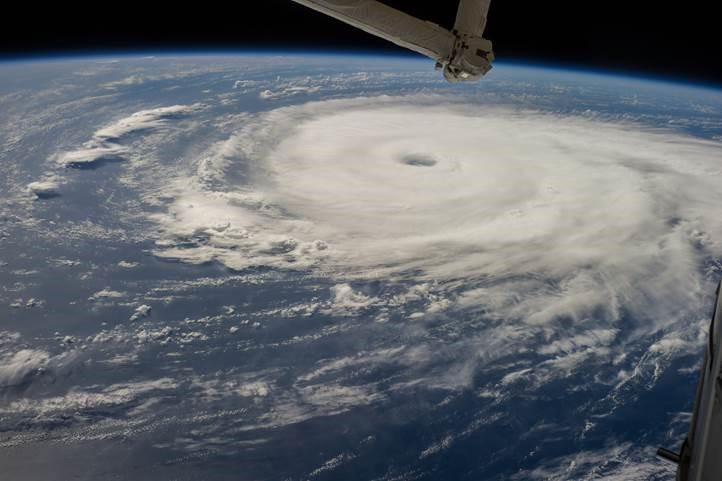
Hurricane Edouard over the Atlantic Ocean, taken from the ISS on September 16, 2014. Image courtesy of Earth Science and Remote Sensing Unit, NASA-JSC
Share
LinkedIn Facebook Twitter Email

Scientists hope that a new project involving photographing tropical cyclones from the International Space Station (ISS) will help them better predict their severity.

Predicting tropical cyclones’ severity in advance can be crucial for the preservation of life and property. Until now this has been done through flying aircraft close to the hurricanes, but these flights are both dangerous and expensive. Scientists are hoping that data from the NASA-led ISS project will help make such flights obsolete. 

Known as the Tropical Cyclone Intensity Measurements from the ISS (CyMISS) project (or, more simply, the Tropical Cyclone project) researchers are leveraging a camera on the ISS to measure cloud tops in the eyewall of a tropical cyclone.

The camera is mounted in the Cupola, a dome-shaped observation module with seven windows, where it takes pictures during ISS overpasses of these storms. 

According to NASA, the physics of tropical cyclones is well understood and by applying these physics to data taken by Earth-orbiting meteorology satellites, the severity of cyclones can be predicted to a high accuracy.

Until now, however, the only missing dataset in the forecasting models is the height measurements of cloud tops within the eyewall. The CyMISS project determines the cloud-top altitudes by applying pseudo-stereoscopy to sequences of photographic images.

According to NASA, “The purpose of the project is to confirm the underlying physics of tropical cyclones, and to validate this new technique for measuring the intensities of tropical cyclones.”

Previous ArticleNew study reveals widespread influence of oceans on Earth’s climate
Next Article Chasing wildfires from space

Read Similar Stories

Extreme Weather

North Sea marine heatwave intensified impacts of Storm Babet by 9-20%

July 21, 20263 Mins Read
Extreme Weather

More than 2,700 estimated excess deaths in England and Wales during May and June heatwaves

July 14, 20263 Mins Read
Climate Measurement

WMO reports record dust storms in China and USA-Mexico border in 2025

July 13, 20263 Mins Read
Latest News

Machine learning opens new possibilities for global atmospheric reanalysis

July 22, 2026

North Sea marine heatwave intensified impacts of Storm Babet by 9-20%

July 21, 2026

FEATURE: UAH study tracks post-wildfire weather shifts

July 21, 2026

Receive breaking stories and features in your inbox each week, for free


Enter your email address:


Supplier Spotlights
  • ZX Lidars
Getting in Touch
  • Contact Us / Advertise
  • Meet the Editors
  • Media Pack
  • Free Weekly E-Newsletter
Our Social Channels
  • Facebook
  • LinkedIn
© 2026 UKi Media & Events a division of UKIP Media & Events Ltd
  • Cookie Policy
  • Privacy Policy
  • Terms and Conditions
  • Notice and Takedown Policy

Type above and press Enter to search. Press Esc to cancel.