Close Menu
Meteorological Technology International
  • News
    • A-E
      • Agriculture
      • Automated Weather Stations
      • Aviation
      • Climate Measurement
      • Data
      • Developing Countries
      • Digital Applications
      • Early Warning Systems
      • Extreme Weather
    • G-P
      • Hydrology
      • Lidar
      • Lightning Detection
      • New Appointments
      • Nowcasting
      • Numerical Weather Prediction
      • Polar Weather
    • R-S
      • Radar
      • Rainfall
      • Remote Sensing
      • Renewable Energy
      • Satellites
      • Solar
      • Space Weather
      • Supercomputers
    • T-Z
      • Training
      • Transport
      • Weather Instruments
      • Wind
      • World Meteorological Organization
      • Meteorological Technology World Expo
  • Features
  • Online Magazines
    • January 2026
    • April 2025
    • January 2025
    • September 2024
    • April 2024
    • Archive Issues
    • Subscribe Free!
  • Opinion
  • Videos
  • Supplier Spotlight
  • Expo
LinkedIn X (Twitter) Facebook
  • Sign-up for Free Weekly E-Newsletter
  • Meet the Editors
  • Contact Us
  • Media Pack
LinkedIn Facebook
Subscribe
Meteorological Technology International
  • News
      • Agriculture
      • Automated Weather Stations
      • Aviation
      • Climate Measurement
      • Data
      • Developing Countries
      • Digital Applications
      • Early Warning Systems
      • Extreme Weather
      • Hydrology
      • Lidar
      • Lightning Detection
      • New Appointments
      • Nowcasting
      • Numerical Weather Prediction
      • Polar Weather
      • Radar
      • Rainfall
      • Remote Sensing
      • Renewable Energy
      • Satellites
      • Solar
      • Space Weather
      • Supercomputers
      • Training
      • Transport
      • Weather Instruments
      • Wind
      • World Meteorological Organization
      • Meteorological Technology World Expo
  • Features
  • Online Magazines
    1. January 2026
    2. September 2025
    3. April 2025
    4. January 2025
    5. September 2024
    6. April 2024
    7. January 2024
    8. September 2023
    9. April 2023
    10. Archive Issues
    11. Subscribe Free!
    Featured
    November 27, 2025

    In this Issue – January 2026

    By Hazel KingNovember 27, 2025
    Recent

    In this Issue – January 2026

    November 27, 2025

    In this Issue – September 2025

    August 11, 2025

    In this Issue – April 2025

    April 15, 2025
  • Opinion
  • Videos
  • Supplier Spotlight
  • Expo
Facebook LinkedIn
Subscribe
Meteorological Technology International
Radar

BoM completes upgrades to Perth and Hobart weather radars

Dan SymondsBy Dan SymondsNovember 30, 20222 Mins Read
Share LinkedIn Facebook Twitter Email
Mt Koonya weather radar in Hobart - credit: Bureau of Meteorology
Share
LinkedIn Facebook Twitter Email

Australia’s Bureau of Meteorology (BoM) has completed a series of upgrades to its weather radars in Hobart (Mt Koonya), Tasmania and Serpentine, Perth. Images from the newly upgraded radars are now live on the bureau’s website and the BOM weather app.

Simon Louis, hazard and preparedness manager – Tasmania, said, “Accurate and timely weather information is critical for local residents and industry, including aviation and resources, in and around Hobart. The upgrades to the weather radar will assist the community to track rain, wind, storms and severe weather with increased confidence.”

Serpentine weather radar in Perth – credit: Bureau of Meteorology

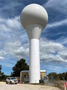
Todd Smith, hazard preparedness manager north and west, said, “Dual-polarized Doppler radars are a tool for observing rainfall and wind conditions in real time across large areas. They show Australians what’s happening right now and provide data as part of the Bureau’s observation network.

“The radar data is also fed into our models and forecasts to deliver rainfall and severe weather warnings, hail location and strength of wind information. This enables businesses to make better decisions when preparing for severe weather, helps farmers make timely decisions, such as movement of stock, chemical and fertilizer application, sowing and harvesting.

“Emergency services will also benefit from better fire plume height estimation and detection of fire-generated thunderstorms.”

The Mt Koonya and Serpentine weather radars are part of a comprehensive weather observation network of more than 11,000 assets including satellites, upper atmosphere monitoring, automatic weather stations, ocean buoys and flood warning networks.

This project is part of the bureau’s ongoing work to enhance and improve the Australian radar and observation network.

Previous ArticleLow-oxygen Pacific waters to expand by 4% due to climate change
Next Article NOAA to leverage Microsoft cloud computing tools to build climate resilience

Read Similar Stories

Radar

EWR Radar Systems wins US Air Force contract for portable Doppler radar support

April 20, 20262 Mins Read
Climate Measurement

The Weather Company updates Storm Radar app with AI features

April 1, 20262 Mins Read
Aviation

Met Office launches platform to support needs of evolving aviation industry

March 24, 20262 Mins Read
Latest News

Extreme heat posing significant risks to ecosystems and agriculture, FAO-WMO report warns

April 22, 2026

Atmospheric G2 secures Japan weather forecasting license

April 21, 2026

China completes Antarctic meteorological research mission with Xuelong icebreaker

April 21, 2026

Receive breaking stories and features in your inbox each week, for free


Enter your email address:


Supplier Spotlights
  • Meteomatics AG
Getting in Touch
  • Contact Us / Advertise
  • Meet the Editors
  • Media Pack
  • Free Weekly E-Newsletter
Our Social Channels
  • Facebook
  • LinkedIn
© 2026 UKi Media & Events a division of UKIP Media & Events Ltd
  • Cookie Policy
  • Privacy Policy
  • Terms and Conditions
  • Notice and Takedown Policy

Type above and press Enter to search. Press Esc to cancel.