


Close Menu
Meteorological Technology International
  • News
    • A-E
      • Agriculture
      • Artificial Intelligence
      • Automated Weather Stations
      • Aviation
      • Climate Measurement
      • Data
      • Developing Countries
      • Digital Applications
      • Early Warning Systems
      • Extreme Weather
    • G-P
      • Hydrology
      • Lidar
      • Lightning Detection
      • New Appointments
      • Nowcasting
      • Numerical Weather Prediction
      • Polar Weather
    • R-S
      • Radar
      • Rainfall
      • Remote Sensing
      • Renewable Energy
      • Satellites
      • Solar
      • Space Weather
      • Supercomputers
    • T-Z
      • Training
      • Transport
      • Weather Instruments
      • Wind
      • World Meteorological Organization
      • Meteorological Technology World Expo
  • Features
  • Online Magazines
    • September 2026
    • January 2026
    • April 2025
    • January 2025
    • September 2024
    • April 2024
    • Archive Issues
    • Subscribe Free!
  • Opinion
  • Videos
  • Supplier Spotlight
  • Expo
LinkedIn X (Twitter) Facebook
  • Sign-up for Free Weekly E-Newsletter
  • Meet the Editors
  • Contact Us
  • Media Pack
LinkedIn Facebook
Subscribe
Meteorological Technology International
  • News
      • Agriculture
      • Artificial Intelligence
      • Automated Weather Stations
      • Aviation
      • Climate Measurement
      • Data
      • Developing Countries
      • Digital Applications
      • Early Warning Systems
      • Extreme Weather
      • Hydrology
      • Lidar
      • Lightning Detection
      • New Appointments
      • Nowcasting
      • Numerical Weather Prediction
      • Polar Weather
      • Radar
      • Rainfall
      • Remote Sensing
      • Renewable Energy
      • Satellites
      • Solar
      • Space Weather
      • Supercomputers
      • Training
      • Transport
      • Weather Instruments
      • Wind
      • World Meteorological Organization
      • Meteorological Technology World Expo
  • Features
  • Online Magazines
    1. September 2026
    2. April 2026
    3. January 2026
    4. September 2025
    5. April 2025
    6. January 2025
    7. September 2024
    8. April 2024
    9. January 2024
    10. Archive Issues
    11. Subscribe Free!
    Featured
    August 4, 2026

    In this Issue – September 2026

    By Web TeamAugust 4, 2026
    Recent

    In this Issue – September 2026

    August 4, 2026

    In this Issue – April 2026

    May 5, 2026

    In this Issue – January 2026

    November 27, 2025
  • Opinion
  • Videos
  • Supplier Spotlight
  • Expo
Facebook LinkedIn
Subscribe
Meteorological Technology International
Early Warning Systems

NOAA flood tool covers nearly 100% of the US

Alex PackBy Alex PackSeptember 25, 20262 Mins Read
Share LinkedIn Facebook Twitter Email
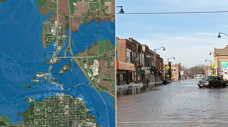
NOAA's National Weather Service has announced that its Flood Inundation Mapping (FIM) tool, used to predict river flooding, is now available on an experimental basis to nearly 100% of the US population, up from 60% previously..
NOAA's flood inundation map (left) depicting the forecast for flooding extent in New London, Wisconsin, and a photo of flooded streets in New London (right), dated April 17, 2026. (Image credit: NOAA NWS)
Share
LinkedIn Facebook Twitter Email

NOAA’s National Weather Service has announced that its Flood Inundation Mapping (FIM) tool, used to predict river flooding, is now available on an experimental basis to nearly 100% of the US population, up from 60% previously.

FIM produces estimates of land area covered in water based on model forecast river flows and current conditions, predicting where flooding impacts may occur in the following days. It is used by forecasters, emergency managers and the public to track river and stream flooding conditions at a neighborhood scale, covering 3.3 million river miles across the continental US, US territories and Hawaii. The latest expansion adds coverage of the southeastern US coast and Florida, the Great Lakes region, New England, the Rocky Mountains, the Dakotas and western Nebraska.

“Inundation maps are a critical tool for assessing the impacts of flooding,” said NOAA administrator Neil Jacobs, PhD. “NOAA prioritized expanding FIM to ensure that nearly every American can access detailed information beyond the expected river crest height. These maps further support NOAA’s mission to protect lives, safeguard property and strengthen our national economy.”

NWS local offices have already used FIM in emergency response. In spring 2025, the NWS office in Nashville, Tennessee used FIM to help a senior assisted living facility in Macon County safely evacuate residents hours before floodwaters arrived. In April 2025, the NWS office in Little Rock, Arkansas, shared FIM with the city of Hardy, which went door to door to evacuate residents and reported a nearly 100% success rate.

“FIM has been a game-changer when briefing emergency managers, first responders and communities facing flood risk,” said National Weather Service director Ken Graham. “It helps focus their response on the extent of flooding by using a strong and precise visualization tool.”

FIM launched in 2023 covering 10% of the US population and reached 60% coverage in 2025. The current expansion does not yet extend to northern and western Alaska, Guam, the Northern Mariana Islands or American Samoa. The maps are publicly available on the National Water Prediction Service website in several GIS file formats.

In related news, New European early warning systems move from emergency alert to actionable insight

Previous ArticleTwo weeks to go until Meteorological Technology World Expo returns to Amsterdam

Read Similar Stories

Automated Weather Stations

Bent Ear Solutions and Western Weather Group link sensor data to utility wildfire decisions

September 25, 20262 Mins Read
Early Warning Systems

New European early warning systems move from emergency alert to actionable insight

September 23, 20263 Mins Read
Climate Measurement

Record-breaking El Niño surpasses previous benchmarks

September 22, 20262 Mins Read
Latest News

NOAA flood tool covers nearly 100% of the US

September 25, 2026

Two weeks to go until Meteorological Technology World Expo returns to Amsterdam

September 25, 2026

Bent Ear Solutions and Western Weather Group link sensor data to utility wildfire decisions

September 25, 2026

Receive breaking stories and features in your inbox each week, for free


Enter your email address:


Supplier Spotlights
  • EWR Radar Systems
Getting in Touch
  • Contact Us / Advertise
  • Meet the Editors
  • Media Pack
  • Free Weekly E-Newsletter
Our Social Channels
  • Facebook
  • LinkedIn
© 2026 UKi Media & Events a division of UKIP Media & Events Ltd
  • Cookie Policy
  • Privacy Policy
  • Terms and Conditions
  • Notice and Takedown Policy

Type above and press Enter to search. Press Esc to cancel.