


Close Menu
Meteorological Technology International
  • News
    • A-E
      • Agriculture
      • Automated Weather Stations
      • Aviation
      • Climate Measurement
      • Data
      • Developing Countries
      • Digital Applications
      • Early Warning Systems
      • Extreme Weather
    • G-P
      • Hydrology
      • Lidar
      • Lightning Detection
      • New Appointments
      • Nowcasting
      • Numerical Weather Prediction
      • Polar Weather
    • R-S
      • Radar
      • Rainfall
      • Remote Sensing
      • Renewable Energy
      • Satellites
      • Solar
      • Space Weather
      • Supercomputers
    • T-Z
      • Training
      • Transport
      • Weather Instruments
      • Wind
      • World Meteorological Organization
      • Meteorological Technology World Expo
  • Features
  • Online Magazines
    • January 2026
    • April 2025
    • January 2025
    • September 2024
    • April 2024
    • Archive Issues
    • Subscribe Free!
  • Opinion
  • Videos
  • Supplier Spotlight
  • Expo
LinkedIn X (Twitter) Facebook
  • Sign-up for Free Weekly E-Newsletter
  • Meet the Editors
  • Contact Us
  • Media Pack
LinkedIn Facebook
Subscribe
Meteorological Technology International
  • News
      • Agriculture
      • Automated Weather Stations
      • Aviation
      • Climate Measurement
      • Data
      • Developing Countries
      • Digital Applications
      • Early Warning Systems
      • Extreme Weather
      • Hydrology
      • Lidar
      • Lightning Detection
      • New Appointments
      • Nowcasting
      • Numerical Weather Prediction
      • Polar Weather
      • Radar
      • Rainfall
      • Remote Sensing
      • Renewable Energy
      • Satellites
      • Solar
      • Space Weather
      • Supercomputers
      • Training
      • Transport
      • Weather Instruments
      • Wind
      • World Meteorological Organization
      • Meteorological Technology World Expo
  • Features
  • Online Magazines
    1. April 2026
    2. January 2026
    3. September 2025
    4. April 2025
    5. January 2025
    6. September 2024
    7. April 2024
    8. January 2024
    9. Archive Issues
    10. Subscribe Free!
    Featured
    May 5, 2026

    In this Issue – April 2026

    By Web TeamMay 5, 2026
    Recent

    In this Issue – April 2026

    May 5, 2026

    In this Issue – January 2026

    November 27, 2025

    In this Issue – September 2025

    August 11, 2025
  • Opinion
  • Videos
  • Supplier Spotlight
  • Expo
Facebook LinkedIn
Subscribe
Meteorological Technology International
Climate Measurement

Xilinhot observatory receives first data from Beidou satellite navigation sounding device

Hazel KingBy Hazel KingJanuary 6, 20252 Mins Read
Share LinkedIn Facebook Twitter Email
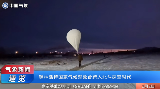
Xilinhot observatory receives first data from Beidou satellite navigation sounding device
Credit: China Meteorological Administration
Share
LinkedIn Facebook Twitter Email

At 7.15am local time on January 1, a balloon carrying a Beidou satellite navigation sounding device was launched at the Xilinhot Upper-air Observatory in Inner Mongolia, China, with the first set of sounding data received 30 minutes later.

The data was uploaded to the meteorological big data cloud platform ‘Tianqing’ for domestic meteorological operational use and marked the official start of the Beidou sounding operation by the observatory to obtain local long-term, continuous and stable vertical atmospheric data.

“It is the first time that Beidou sounding operational data has been applied to upper-air baseline climate observation,” said Guo Qiyun, deputy director of the base room of China Meteorological Administration (CMA) Meteorological Observation Centre (MOC).

The Global Climate Observing System (GCOS) upper-air base observing network site map shows more than 30 sites scattered across five continents and seven oceans, of which only four are in Asia. The Xilinhot observatory is the only GCOS upper-air baseline climate observatory in north-central Asia and the only one on the Chinese mainland. It is located in China’s northern grasslands and on the transit path of cold air, which is a key node in the study of climate change and the impacts of human activities in the typical climatic zone of semi-arid continental areas in the mesothermal temperate zone.

“Carrying out upper-air baseline climate observations here can provide validation tests for remote sensing observation methods such as Fengyun meteorological satellites and provide constraints on the quality of global vertical observation networks and gridded forecast data,” confirmed Kang Li, director of the office of observations and networks of the Inner Mongolia Autonomous Region Meteorological Service.

Previous ArticleVIDEO: MicroStep-MIS and Slovak government develop complex water management systems
Next Article WMO launches WIS 2.0 to transform Earth system data sharing

Read Similar Stories

Satellites

SMILE mission launches to study Earth’s magnetic shield and space weather

May 20, 20263 Mins Read
Climate Measurement

Cloud measurement campaign targets improved climate model accuracy

May 20, 20263 Mins Read
Videos

VIDEO: Meteosat-12 imagery over Europe and Africa made available via YouTube streams

May 19, 20262 Mins Read
Latest News

SMILE mission launches to study Earth’s magnetic shield and space weather

May 20, 2026

Cloud measurement campaign targets improved climate model accuracy

May 20, 2026

VIDEO: Meteosat-12 imagery over Europe and Africa made available via YouTube streams

May 19, 2026

Receive breaking stories and features in your inbox each week, for free


Enter your email address:


Supplier Spotlights
  • Raymetrics
Getting in Touch
  • Contact Us / Advertise
  • Meet the Editors
  • Media Pack
  • Free Weekly E-Newsletter
Our Social Channels
  • Facebook
  • LinkedIn
© 2026 UKi Media & Events a division of UKIP Media & Events Ltd
  • Cookie Policy
  • Privacy Policy
  • Terms and Conditions
  • Notice and Takedown Policy

Type above and press Enter to search. Press Esc to cancel.