


Early thunderstorm warning remains a difficult operational problem in meteorology because the requirement is not simply to detect lightning but to distinguish evolving convective risk early enough to support a meaningful decision. In many operational settings, the critical question is not whether a flash has already occurred, but whether atmospheric electrical conditions are developing toward a state that threatens personnel, infrastructure or continuity of operations.
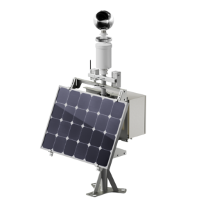
Senseca’s BTD-1 has been developed around that requirement. It combines sensitive lightning detection with overhead pre-flash warning, configurable risk outputs and modular deployment options in a compact field instrument intended for fixed outdoor installation. The system detects cloud-to-ground, intra-cloud and cloud-to-cloud lightning, while also responding to charged precipitation and strong electric-field conditions associated with overhead thunderstorm development. In practical terms, this means it is designed to support warning before the first local strike, rather than only reporting lightning once the hazard has fully matured.
Detection physics and warning philosophy
A notable feature of the BTD approach is its emphasis on capturing the complete intra-cloud lightning activity and electrostatic signatures of overhead development even before the first flash occurs. The system analyzes electric field variability below 50Hz to detect and range lightning discharges, taking advantage of the relatively low level of electrical noise in this band. This is an important design choice. In operational meteorology, intra-cloud lightning often provides an earlier indication of convective electrification than cloud-to-ground activity alone, and therefore has value in warning systems intended to support preemptive action. The same extremely low-frequency approach also contributes to low false alarms compared with systems that rely on higher-frequency radio or secondary optical flash confirmation to suppress spurious events.
Published performance figures indicate a detection efficiency of 95% for a single lightning flash and 99% for a storm producing at least two flashes, with a false alarm rate below 2%. The instrument provides a maximum update rate of two seconds and supports lightning detection to 35km in its standard configuration, extendable to 83km via software activation. Range resolution is specified at 10m, with ranging errors of ±5km between 0km and 20km and ±10km between 20km and 83km. These parameters allow individual storm cells to be identified and tracked, placing the instrument in the category of operational warning systems rather than purely indicative storm alarms.
Pre-warning of overhead convective risk
A central operational capability is overhead pre-warning. The system monitors background conditions associated with cumulonimbus (thundercloud) formation and issues a warning of developing thunderstorm conditions before nearby lightning occurs. The technical rationale is straightforward: overhead charged precipitation and strong electric field development can indicate that the local atmospheric column is becoming electrically active even before the first strike is registered at the site. This is important since roughly one in five overhead cumulonimbus clouds subsequently produce their first lightning flash nearby, making such pre-warning particularly relevant for safety-critical use cases.
For meteorological operators, this changes the function of the instrument from simple event detection to actionable situational awareness. The BTD-1 not only indicates lightning occurrence but also contributes to a staged interpretation of deep convective evolution surrounding the site.
Risk-state logic and severe storm indication
This staged interpretation is reflected in the configurable risk framework. The BTD-1 supports four risk states – All Clear, Caution, Warning and Alert – and allows pre-warning to be mapped to different outputs according to the operator’s risk appetite and operational doctrine. This is significant because not all exposed sites treat thunderstorm risk in the same way. A fuel transfer station, airport apron, wind energy site and synoptic observing station may all require different thresholds for operational intervention. The configurable warning logic therefore supports adaptation to application-specific procedures rather than enforcing a single fixed-response model.
The system also includes a severe storm feature intended to identify storms more likely to contain large hailstones and strong downdrafts. The underlying principle is that high lightning flash rates are associated with more severe convective structures. That makes the BTD-1 relevant not only to personnel lightning safety but also to asset protection in environments where hail and wind damage are operational concerns. This is particularly pertinent for exposed installations such as solar farms, where the economic consequence of severe convection extends beyond temporary shutdown to expensive physical damage.
Integration and field deployment
The BTD-1 has been designed for ease of installation. The standard interface is Serial RS422 via M12 connectors, with an ASCII text API for systems integrators and three assignable relay outputs for connection into local control or alarm architectures. Power is supplied at 9-36V DC, and default power consumption is below 5W. An optional PoE module replaces the RS422 interface, allowing power and ethernet connectivity over a single cable where integration into existing infrastructure is preferred.
The wider deployment ecosystem includes a field mounting kit, solar kit, radio module and direction finder. Wireless transmission is supported up to 200m, and the solar configuration is intended for remote sites where conventional power is not readily available. Ease of installation includes preassembled leads and plug-and-play installation logic, with a complete base package, including sensor, power and data cables, AC-DC supply, serial-to-USB converter and Senseca’s new Lightning Eye software.
Software, diagnostics and maintainability
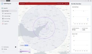
The software environment is intended to support both operational visibility and system management. Lightning Eye provides real-time visualization, map overlay, lightning history graphing, diagnostics, system configuration, automatic datalogging and export functions. Remote connectivity is supported, as well as GPS/GNSS integration for accurate flash timing and sensor location. For systems requiring on-site operational verification, an internal flash signal generator is available to support remote hardware checking without the need for a site visit.
The BTD-1 is designed for durability and a long lifetime. The instrument contains no moving parts, includes self-test capability as standard, and is virtually maintenance-free apart from periodic inspection and cleaning. Environmental specifications include operation from -20°C to +50°C, IP66 protection, 0-100% relative humidity and wind speeds up to 60m/s, with an optional extreme heating mode increasing power to 50W for very cold or wet installations.
Building on the extremely high flash-detection efficiency of BTD products, the BTD-1 combines multiple features into one operational platform: overhead pre-warning, multi-type lightning detection, configurable risk-state logic, severe-storm indication and practical field deployment. The result is a system positioned not merely to detect thunderstorms but to support operational decisions in the period when action is still possible.