


More than 700 million people on our planet are exposed to tsunamis, but new technological advancements and international cooperation efforts will make future tsunami warnings more timely, accurate and accessible to all those at risk.
In 2004, when the Indian Ocean Tsunami hit 14 countries and killed more than 230,000 people, there was no tsunami warning system present in the Indian Ocean – nor in many other regions. “In fact, apart from the Pacific, there was almost no exchange of real-time data that is needed for tsunami warnings, and no deep-ocean monitoring systems in place,” says Denis Chang Seng, program specialist for the Tsunami Resilience Section at the Intergovernmental Oceanographic Commission of UNESCO (IOC/UNESCO).
Fast forward to 2023, the progress of tsunami warning systems has been tremendous. “Today, there are regional Tsunami Warning Systems in each of the four major ocean basins, with a total of 11 Tsunami Service Providers issuing tsunami threat advice to Tsunami Warning Centers established in each country,” says Rick Bailey, head of secretariat for the IOC/UNESCO Intergovernmental Coordination Group for the Indian Ocean Tsunami Warning and Mitigation System (ICG/IOTWMS).
Many coastal areas now receive tsunami threat advice within 10 to 20 minutes after a potentially tsunami-generating undersea earthquake is detected. “It is still technically challenging, however, to generate a timely and accurate tsunami warning in a short amount of time in the case of major earthquakes, and especially if the epicenter is not far from the coast,” says Chang Seng.
Tsunamis are known for their high speed – in deep water they are small and can move as fast as a jet plane, crossing entire oceans in less than a day, before slowing down and shoaling to greater heights in shallow water. In this race against time, every minute lost in receiving a warning can lead to a devastating toll on human lives – but various new technological advancements hold the key to ensuring swifter and more accurate tsunami alerts even in the most challenging cases. Below are some of the developments that are shaping the future of tsunami warnings.
Advancing technologies for faster warnings
Tsunameters – instruments that detect and measure tsunamis by monitoring changes in ocean bottom pressure caused by tsunami waves – are often placed thousands of meters deep at the bottom of the ocean. They are connected to surface buoys, which then transmit the data to monitoring centers in real time via satellites.
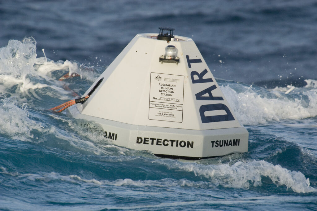
The usual tsunameters have to be placed one hour of tsunami travel time from active seismic zones to prevent their sensors from getting overwhelmed by the massive intensity of earthquake-generated seismic waves. “That’s a problem if we want to detect a tsunami as quickly as possible,” says Mike Angove, tsunami program manager at the US National Oceanic and Atmospheric Administration (NOAA).
Fortunately, a new noise–filtering mechanism developed by the NOAA Pacific Marine Environmental Laboratory allows placing the tsunameters as close as 10 minutes away from the earthquake source, this way greatly reducing the delay in tsunami warnings. “New Zealand is a pioneer that already has these improved instruments in place, and we are excited to try and scale this development up, so that the service is available globally – resources permitting,” says Angove.
Piggybacking on undersea telecommunications cables
Another piece of the technology puzzle could be offered by taking advantage of undersea telecommunications cables. A network of such cables has been used since the mid-19th century to enable international phone calls, data transfers, high-speed internet connectivity and other telecommunications services between countries. Now, the global ocean observing community is hoping to make use of these cables for improved tsunami detection and even to support climate research.
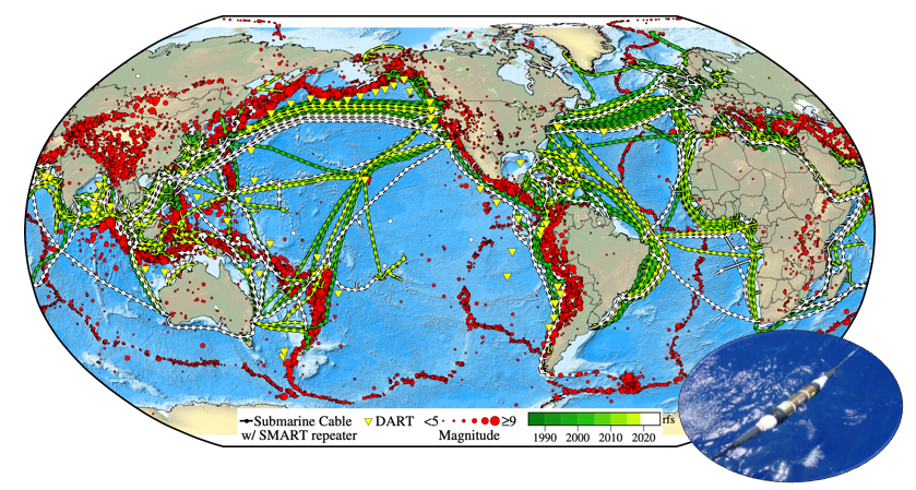
The idea of making use of undersea telecommunications cables for collecting and transmitting data from the bottom of the ocean gave rise to a new project under the Global Ocean Observing System (GOOS), called Science Monitoring And Reliable Telecommunications (SMART) Cables.
“What we want to do is work in partnership with governments and telecommunications companies to place sensors for ocean bottom temperature, pressure and seismic acceleration, roughly every 70km along the undersea cables,” says Bruce Howe, chair of the Joint Task Force (JTF) for SMART Cables for Observing the Ocean, and professor at the University of Hawaii.
“Having these three simple sensors will help us study various topics such as climate change, sea level rise, and ocean circulation, as well as contribute to improved tsunami and earthquake warnings.”
Portugal is one of the first countries to allocate government funds to deploy SMART cables that will connect the Portuguese mainland with the archipelagos of Azores and Madeira in the SMART Atlantic CAM (Continent-Azores-Madeira) system, which will become operational in 2026.
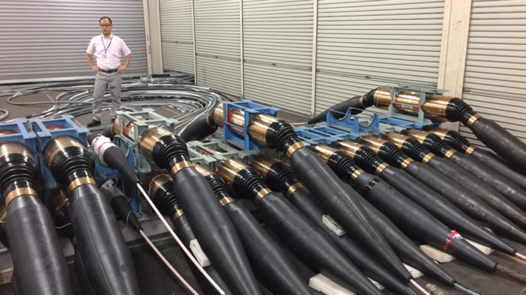
“While Portugal may not be in people’s minds as one of the countries with the highest tsunami hazard, back in 1755 a huge tsunami destroyed Lisbon,” says Fernando Carrilho, head of the geophysics division at the Portuguese Institute for the Ocean and Atmosphere (IPMA). “We have a long, exposed coastline, and offshore earthquakes are relatively common,” he adds.
While the initial cost of deploying sensors on cable systems is large, it is much reduced when taking a long perspective across the 25-year lifetime of SMART Cables – and the benefits can be priceless. “For example, each Portuguese citizen would pay a total of €1.50 (US$2) for 25 years of protection,” says Howe.
By working together with the IOC/UNESCO Tsunami Resilience Section and GOOS, Portugal is planning to make the valuable data collected through SMART cables available to the international community. This will allow other countries of the North-Eastern Atlantic and the Mediterranean to benefit from improved tsunami warnings, as well as help the global scientific community better understand these catastrophic events.
Capacity development – building out the core network
“New, advanced technology is great. But tried-and-tested sea level stations are still at the core of the tsunami warning system,” says Bernardo Aliaga, head of the IOC/UNESCO TRS and Technical Secretary of the Group of Experts for the Global Sea Level Observing System (GLOSS). However, there are some serious gaps in their coverage. “The Northern Hemisphere has around one sea level station every 50km of coastline, but the African continent and areas such as the Southwest Pacific are much less covered,” says Aliaga.
One sea level station with basic instrumentation could cost as little as US$5,000, and Aliaga suggests the gaps in global sea level station coverage are not a simple matter of money. “It is actually a matter of capacity development. There have to be people who will keep the stations working, calibrate and quality control them – and it takes time and additional resources to get them trained,” he says.
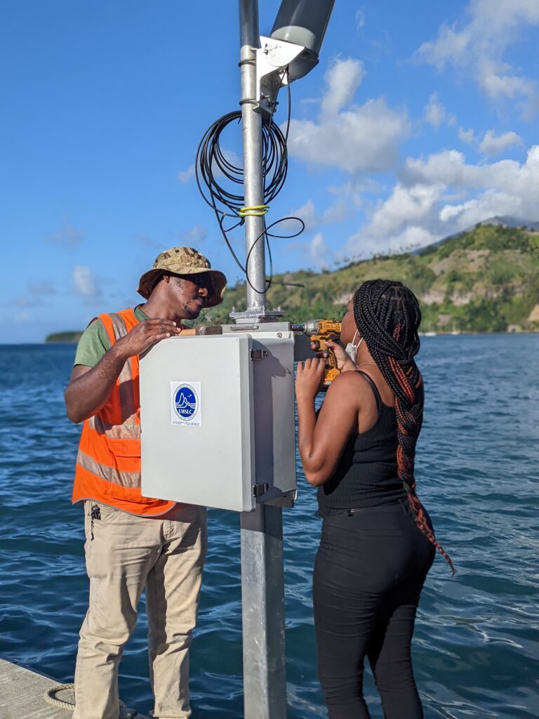
Success stories from the activities carried out by the GLOSS network team clearly show the impact capacity development can have in helping to establish tsunami warning systems in countries where they were lacking. “We started our capacity development activities in the Caribbean in 2006 with no more than 10 sea level stations available for the entire region,” says Aliaga. “There was no system in place to inform the population about a coming storm surge, or a tsunami. But in a few years, the Caribbean region had 70 stations working to protect the local communities,” says Aliaga.
Coordination: the key to preventing disaster
A tsunami can affect much more than one country. The 2004 Indian Ocean Tsunami originated near Sumatra in Indonesia and traveled halfway around the world, reaching as far as African coasts. With such situations in mind, the need for cooperation and data sharing between nations could not be clearer.
“GOOS has a crucial role to play in coordinating and promoting the sharing of real-time data, as well as ensuring the data meets the objectives of a range of applications – including tsunami warnings,” says Emma Heslop, GOOS acting office director. “This will allow us to achieve the greatest utility and cost-effective use of this life-saving information.”
As SMART Cables develop, the deep ocean tsunameter buoy systems could then be redeployed to areas that are not covered by undersea cables. “It takes international coordination to support capacity development, fast track promising new technology, and ensure all regions are adequately covered,’’ says Heslop.
Though relatively rare, large tsunamis wield catastrophic consequences. Yet, with recent strides in ocean observing technology, capacity development, and a growing recognition of the importance of global coordination, faster, more precise and accessible tsunami alerts are within reach – promising a safer future for millions worldwide.