

Close Menu
Meteorological Technology International
  • News
    • A-E
      • Agriculture
      • Automated Weather Stations
      • Aviation
      • Climate Measurement
      • Data
      • Developing Countries
      • Digital Applications
      • Early Warning Systems
      • Extreme Weather
    • G-P
      • Hydrology
      • Lidar
      • Lightning Detection
      • New Appointments
      • Nowcasting
      • Numerical Weather Prediction
      • Polar Weather
    • R-S
      • Radar
      • Rainfall
      • Remote Sensing
      • Renewable Energy
      • Satellites
      • Solar
      • Space Weather
      • Supercomputers
    • T-Z
      • Training
      • Transport
      • Weather Instruments
      • Wind
      • World Meteorological Organization
      • Meteorological Technology World Expo
  • Features
  • Online Magazines
    • January 2026
    • April 2025
    • January 2025
    • September 2024
    • April 2024
    • Archive Issues
    • Subscribe Free!
  • Opinion
  • Videos
  • Supplier Spotlight
  • Expo
LinkedIn X (Twitter) Facebook
  • Sign-up for Free Weekly E-Newsletter
  • Meet the Editors
  • Contact Us
  • Media Pack
LinkedIn Facebook
Subscribe
Meteorological Technology International
  • News
      • Agriculture
      • Automated Weather Stations
      • Aviation
      • Climate Measurement
      • Data
      • Developing Countries
      • Digital Applications
      • Early Warning Systems
      • Extreme Weather
      • Hydrology
      • Lidar
      • Lightning Detection
      • New Appointments
      • Nowcasting
      • Numerical Weather Prediction
      • Polar Weather
      • Radar
      • Rainfall
      • Remote Sensing
      • Renewable Energy
      • Satellites
      • Solar
      • Space Weather
      • Supercomputers
      • Training
      • Transport
      • Weather Instruments
      • Wind
      • World Meteorological Organization
      • Meteorological Technology World Expo
  • Features
  • Online Magazines
    1. April 2026
    2. January 2026
    3. September 2025
    4. April 2025
    5. January 2025
    6. September 2024
    7. April 2024
    8. January 2024
    9. Archive Issues
    10. Subscribe Free!
    Featured
    May 5, 2026

    In this Issue – April 2026

    By Web TeamMay 5, 2026
    Recent

    In this Issue – April 2026

    May 5, 2026

    In this Issue – January 2026

    November 27, 2025

    In this Issue – September 2025

    August 11, 2025
  • Opinion
  • Videos
  • Supplier Spotlight
  • Expo
Facebook LinkedIn
Subscribe
Meteorological Technology International
Satellites

NASA selects Ball Aerospace to develop NOAA’s GeoXO Sounder

William AtkinsonBy William AtkinsonSeptember 13, 20232 Mins Read
Share LinkedIn Facebook Twitter Email
Credit NOAA-NASA
Share
LinkedIn Facebook Twitter Email

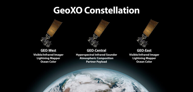
NASA, on behalf of NOAA, has selected Ball Aerospace & Technologies Corporation of Boulder, Colorado, to develop the sounder instrument for a geostationary extended observations (GeoXO) satellite program.

This cost-plus-award-fee contract is valued at US$486.9m and includes the build, delivery, spacecraft integration and post-delivery support for one flight instrument, as well as options for additional units. The anticipated period of performance for this contract includes support for 10 years of on-orbit operations and five years of on-orbit storage, for a total of 15 years for each flight instrument.

The contract scope includes tasks and deliverables necessary to design, analyze, develop, fabricate, integrate, calibrate, test, verify, evaluate, support launch, supply and maintain the instrument ground support equipment, and support mission operations at the NOAA Satellite Operations Facility in Suitland, Maryland.

The GeoXO Sounder (GXS) is a hyperspectral infrared instrument, a camera-like device that has many channels to detect wavelengths of infrared light. It will provide real-time information about the vertical distribution of atmospheric moisture, temperature and winds over the western hemisphere. The US National Weather Service will use GXS data to improve weather prediction and short-term forecasts of convection and severe weather. The National Hurricane Center will use the data to improve hurricane track and intensity forecasts.

NOAA and NASA will oversee the development, launch, testing and operation of all the satellites in the GeoXO program. NOAA funds and manages the program, operations and data products. NASA and commercial partners develop and build the instruments and spacecraft and launch the satellites.

It is intended that the system be operational by the early 2030s, when the GOES-R series nears the end of its operational lifetime.

Previous ArticleSaildrone and NOAA set Guinness World Record
Next Article NOAA selects FLYHT aircraft sensors to help improve US weather forecasting

Read Similar Stories

Weather Instruments

R.M. Young Company reengineers SNOdar snow-depth sensor

May 21, 20262 Mins Read
Satellites

SMILE mission launches to study Earth’s magnetic shield and space weather

May 20, 20263 Mins Read
Climate Measurement

Cloud measurement campaign targets improved climate model accuracy

May 20, 20263 Mins Read
Latest News

R.M. Young Company reengineers SNOdar snow-depth sensor

May 21, 2026

SMILE mission launches to study Earth’s magnetic shield and space weather

May 20, 2026

Cloud measurement campaign targets improved climate model accuracy

May 20, 2026

Receive breaking stories and features in your inbox each week, for free


Enter your email address:


Supplier Spotlights
  • Nel Hydrogen
Getting in Touch
  • Contact Us / Advertise
  • Meet the Editors
  • Media Pack
  • Free Weekly E-Newsletter
Our Social Channels
  • Facebook
  • LinkedIn
© 2026 UKi Media & Events a division of UKIP Media & Events Ltd
  • Cookie Policy
  • Privacy Policy
  • Terms and Conditions
  • Notice and Takedown Policy

Type above and press Enter to search. Press Esc to cancel.