


Close Menu
Meteorological Technology International
  • News
    • A-E
      • Agriculture
      • Artificial Intelligence
      • Automated Weather Stations
      • Aviation
      • Climate Measurement
      • Data
      • Developing Countries
      • Digital Applications
      • Early Warning Systems
      • Extreme Weather
    • G-P
      • Hydrology
      • Lidar
      • Lightning Detection
      • New Appointments
      • Nowcasting
      • Numerical Weather Prediction
      • Polar Weather
    • R-S
      • Radar
      • Rainfall
      • Remote Sensing
      • Renewable Energy
      • Satellites
      • Solar
      • Space Weather
      • Supercomputers
    • T-Z
      • Training
      • Transport
      • Weather Instruments
      • Wind
      • World Meteorological Organization
      • Meteorological Technology World Expo
  • Features
  • Online Magazines
    • January 2026
    • April 2025
    • January 2025
    • September 2024
    • April 2024
    • Archive Issues
    • Subscribe Free!
  • Opinion
  • Videos
  • Supplier Spotlight
  • Expo
LinkedIn X (Twitter) Facebook
  • Sign-up for Free Weekly E-Newsletter
  • Meet the Editors
  • Contact Us
  • Media Pack
LinkedIn Facebook
Subscribe
Meteorological Technology International
  • News
      • Agriculture
      • Artificial Intelligence
      • Automated Weather Stations
      • Aviation
      • Climate Measurement
      • Data
      • Developing Countries
      • Digital Applications
      • Early Warning Systems
      • Extreme Weather
      • Hydrology
      • Lidar
      • Lightning Detection
      • New Appointments
      • Nowcasting
      • Numerical Weather Prediction
      • Polar Weather
      • Radar
      • Rainfall
      • Remote Sensing
      • Renewable Energy
      • Satellites
      • Solar
      • Space Weather
      • Supercomputers
      • Training
      • Transport
      • Weather Instruments
      • Wind
      • World Meteorological Organization
      • Meteorological Technology World Expo
  • Features
  • Online Magazines
    1. April 2026
    2. January 2026
    3. September 2025
    4. April 2025
    5. January 2025
    6. September 2024
    7. April 2024
    8. January 2024
    9. Archive Issues
    10. Subscribe Free!
    Featured
    May 5, 2026

    In this Issue – April 2026

    By Web TeamMay 5, 2026
    Recent

    In this Issue – April 2026

    May 5, 2026

    In this Issue – January 2026

    November 27, 2025

    In this Issue – September 2025

    August 11, 2025
  • Opinion
  • Videos
  • Supplier Spotlight
  • Expo
Facebook LinkedIn
Subscribe
Meteorological Technology International
Extreme Weather

NASA’S JPL lab releases a new view of Hurricane Dorian from mini satellite

Helen NormanBy Helen NormanSeptember 11, 20192 Mins Read
Share LinkedIn Facebook Twitter Email
Share
LinkedIn Facebook Twitter Email

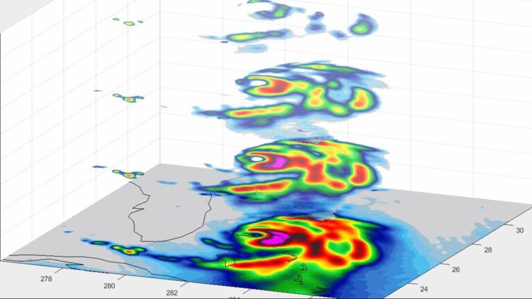
NASA’s Jet Propulsion Lab’s (JPL) mini weather satellite, which is the size of a cereal box, has revealed a new view of Hurricane Dorian showing rain bands in four layers of the storm as it approached Florida on September 3, 2019. The multiple vertical layers show where the strongest convective ‘storms’ within the hurricane are pushing high into the atmosphere, with pink, red and yellow corresponding to the areas of heaviest rainfall.

Known as a CubeSat, TEMPEST-D (Temporal Experiment for Storms and Tropical Systems Demonstration) uses a miniaturized version of a microwave radiometer – a radio wave instrument used to measure rain and moisture within the clouds. According to JPL, if TEMPEST-D can successfully track storms like Dorian, the technology demonstration could lead to a train of small satellites that work together to track storms around the world. CubeSats are much less expensive to produce than traditional satellites; in multiples they could improve global storm coverage and forecasting data.

TEMPEST-D is led by Colorado State University in Fort Collins and managed by JPL in partnership with Blue Canyon Technologies in Boulder, Colorado, and Wallops Flight Facility in Virginia. The mission is sponsored by NASA’s Earth Ventures program and managed by the Earth Science Technology Office at NASA’s headquarters in Washington. The radiometer instrument was built by JPL and employs high-frequency microwave amplifier technology developed by Northrop Grumman.

Previous ArticleACOEM scales up air monitoring capabilities with acquisition of DynOptic Systems
Next Article WMO urges industry to invest in early warning to deliver climate adaptation

Read Similar Stories

Digital Applications

Copernicus launches Fire Emissions Watch tool for global wildfire data

July 31, 20262 Mins Read
Artificial Intelligence

CMA launches MAZU-FengYun Satellite AI Box to strengthen global early warning systems

July 24, 20262 Mins Read
Early Warning Systems

NOAA and SpectraRep to evaluate broadcast datacasting for weather radio resiliency

July 23, 20262 Mins Read
Latest News

Copernicus launches Fire Emissions Watch tool for global wildfire data

July 31, 2026

Climate models misrepresent key cloud behavior during El Niño, study finds

July 30, 2026

NOAA to move weather forecasting supercomputing to Google Cloud

July 28, 2026

Receive breaking stories and features in your inbox each week, for free


Enter your email address:


Supplier Spotlights
  • IACIT
Getting in Touch
  • Contact Us / Advertise
  • Meet the Editors
  • Media Pack
  • Free Weekly E-Newsletter
Our Social Channels
  • Facebook
  • LinkedIn
© 2026 UKi Media & Events a division of UKIP Media & Events Ltd
  • Cookie Policy
  • Privacy Policy
  • Terms and Conditions
  • Notice and Takedown Policy

Type above and press Enter to search. Press Esc to cancel.