Close Menu
Meteorological Technology International
  • News
    • A-E
      • Agriculture
      • Automated Weather Stations
      • Aviation
      • Climate Measurement
      • Data
      • Developing Countries
      • Digital Applications
      • Early Warning Systems
      • Extreme Weather
    • G-P
      • Hydrology
      • Lidar
      • Lightning Detection
      • New Appointments
      • Nowcasting
      • Numerical Weather Prediction
      • Polar Weather
    • R-S
      • Radar
      • Rainfall
      • Remote Sensing
      • Renewable Energy
      • Satellites
      • Solar
      • Space Weather
      • Supercomputers
    • T-Z
      • Training
      • Transport
      • Weather Instruments
      • Wind
      • World Meteorological Organization
      • Meteorological Technology World Expo
  • Features
  • Online Magazines
    • January 2026
    • April 2025
    • January 2025
    • September 2024
    • April 2024
    • Archive Issues
    • Subscribe Free!
  • Opinion
  • Videos
  • Supplier Spotlight
  • Expo
LinkedIn X (Twitter) Facebook
  • Sign-up for Free Weekly E-Newsletter
  • Meet the Editors
  • Contact Us
  • Media Pack
LinkedIn Facebook
Subscribe
Meteorological Technology International
  • News
      • Agriculture
      • Automated Weather Stations
      • Aviation
      • Climate Measurement
      • Data
      • Developing Countries
      • Digital Applications
      • Early Warning Systems
      • Extreme Weather
      • Hydrology
      • Lidar
      • Lightning Detection
      • New Appointments
      • Nowcasting
      • Numerical Weather Prediction
      • Polar Weather
      • Radar
      • Rainfall
      • Remote Sensing
      • Renewable Energy
      • Satellites
      • Solar
      • Space Weather
      • Supercomputers
      • Training
      • Transport
      • Weather Instruments
      • Wind
      • World Meteorological Organization
      • Meteorological Technology World Expo
  • Features
  • Online Magazines
    1. January 2026
    2. September 2025
    3. April 2025
    4. January 2025
    5. September 2024
    6. April 2024
    7. January 2024
    8. September 2023
    9. April 2023
    10. Archive Issues
    11. Subscribe Free!
    Featured
    November 27, 2025

    In this Issue – January 2026

    By Hazel KingNovember 27, 2025
    Recent

    In this Issue – January 2026

    November 27, 2025

    In this Issue – September 2025

    August 11, 2025

    In this Issue – April 2025

    April 15, 2025
  • Opinion
  • Videos
  • Supplier Spotlight
  • Expo
Facebook LinkedIn
Subscribe
Meteorological Technology International
Climate Measurement

Sea-level rise during 20th century fastest in 2,000 years on US Atlantic coast

Helen NormanBy Helen NormanMarch 30, 20213 Mins Read
Share LinkedIn Facebook Twitter Email
Sea-level rise leads to increased flooding at the Edwin B Forsythe National Wildlife Refuge. These photos show approximately the same view in October (left) and September 2016. Credit: Jennifer S Walker
Share
LinkedIn Facebook Twitter Email

A study led by Rutgers University in New Jersey, US, has revealed that the rate of sea-level rise from melting ice and warming oceans in the 20th century along much of the US Atlantic coast was the fastest in 2,000 years. The study also found that southern New Jersey had the fastest rates.

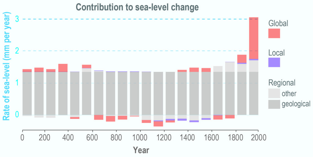
The study looked at the phenomena that contributed to sea-level change over 2,000 years at six sites along the coast in Connecticut, New York City, New Jersey and North Carolina. The study used a sea-level budget, which enhances understanding of the processes driving sea-level change. The processes are global, regional (including geological, such as land subsidence) and local, such as groundwater withdrawal.

The total rate of sea-level rise for each of the six sites in the 20th century (ranging from 2.6mm to 3.6mm per year, or about 1in to 1.4in per decade) was the fastest in 2,000 years. Southern New Jersey had the fastest rates over the 2,000-year period: 1.6mm a year (about 0.63in per decade) at Edwin B. Forsythe National Wildlife Refuge, Leeds Point, in Atlantic County, and 1.5mm a year (about 0.6in per decade) at Cape May Court House, Cape May County.

Rutgers University
Sea-level budget for northern New Jersey over the past 2,000 years. Image: Rutgers University/Earth Observatory of Singapore

“Having a thorough understanding of sea-level change at sites over the long term is imperative for regional and local planning and responding to future sea-level rise,” said lead author Jennifer S Walker, a postdoctoral associate in the Department of Earth and Planetary Sciences in the School of Arts and Sciences at Rutgers University – New Brunswick. “By learning  how different processes vary over time and contribute to sea-level change, we can more accurately estimate future contributions at specific sites.”

Most sea-level budget studies are global and limited to the 20th and 21st centuries. Rutgers-led researchers estimated sea-level budgets for longer time frames over 2,000 years. The goal was to better understand how the processes driving sea level have changed and could shape future change, and this sea-level budget method could be applied to other sites around the world.

Using a statistical model, scientists developed sea-level budgets for six sites, dividing sea-level records into global, regional and local components. They found that regional land subsidence – sinking of the land since the Laurentide ice sheet retreated thousands of years ago – dominates each site’s budget over the past 2,000 years. Other regional factors, such as ocean dynamics, and site-specific local processes, such as groundwater withdrawal that helps cause land to sink, contribute much less to each budget and vary over time and by location.

The full study can be found here: Common Era sea-level budgets along the U.S. Atlantic coast.

Previous ArticleWorldwide weather: why local forecasting needs global data from nanosatellites
Next Article Key achievements from High Impact Weather Lake System project

Read Similar Stories

Climate Measurement

WMO signals increasing likelihood of El Niño developing in 2026

April 24, 20263 Mins Read
Radar

Alabama partners with Climavision to expand weather radar coverage statewide

April 24, 20262 Mins Read
Climate Measurement

China completes Antarctic meteorological research mission with Xuelong icebreaker

April 21, 20262 Mins Read
Latest News

WMO signals increasing likelihood of El Niño developing in 2026

April 24, 2026

Alabama partners with Climavision to expand weather radar coverage statewide

April 24, 2026

Extreme heat posing significant risks to ecosystems and agriculture, FAO-WMO report warns

April 22, 2026

Receive breaking stories and features in your inbox each week, for free


Enter your email address:


Supplier Spotlights
  • Geolux d.o.o.
Getting in Touch
  • Contact Us / Advertise
  • Meet the Editors
  • Media Pack
  • Free Weekly E-Newsletter
Our Social Channels
  • Facebook
  • LinkedIn
© 2026 UKi Media & Events a division of UKIP Media & Events Ltd
  • Cookie Policy
  • Privacy Policy
  • Terms and Conditions
  • Notice and Takedown Policy

Type above and press Enter to search. Press Esc to cancel.