Close Menu
Meteorological Technology International
  • News
    • A-E
      • Agriculture
      • Automated Weather Stations
      • Aviation
      • Climate Measurement
      • Data
      • Developing Countries
      • Digital Applications
      • Early Warning Systems
      • Extreme Weather
    • G-P
      • Hydrology
      • Lidar
      • Lightning Detection
      • New Appointments
      • Nowcasting
      • Numerical Weather Prediction
      • Polar Weather
    • R-S
      • Radar
      • Rainfall
      • Remote Sensing
      • Renewable Energy
      • Satellites
      • Solar
      • Space Weather
      • Supercomputers
    • T-Z
      • Training
      • Transport
      • Weather Instruments
      • Wind
      • World Meteorological Organization
      • Meteorological Technology World Expo
  • Features
  • Online Magazines
    • January 2026
    • April 2025
    • January 2025
    • September 2024
    • April 2024
    • Archive Issues
    • Subscribe Free!
  • Opinion
  • Videos
  • Supplier Spotlight
  • Expo
LinkedIn X (Twitter) Facebook
  • Sign-up for Free Weekly E-Newsletter
  • Meet the Editors
  • Contact Us
  • Media Pack
LinkedIn Facebook
Subscribe
Meteorological Technology International
  • News
      • Agriculture
      • Automated Weather Stations
      • Aviation
      • Climate Measurement
      • Data
      • Developing Countries
      • Digital Applications
      • Early Warning Systems
      • Extreme Weather
      • Hydrology
      • Lidar
      • Lightning Detection
      • New Appointments
      • Nowcasting
      • Numerical Weather Prediction
      • Polar Weather
      • Radar
      • Rainfall
      • Remote Sensing
      • Renewable Energy
      • Satellites
      • Solar
      • Space Weather
      • Supercomputers
      • Training
      • Transport
      • Weather Instruments
      • Wind
      • World Meteorological Organization
      • Meteorological Technology World Expo
  • Features
  • Online Magazines
    1. January 2026
    2. September 2025
    3. April 2025
    4. January 2025
    5. September 2024
    6. April 2024
    7. January 2024
    8. September 2023
    9. April 2023
    10. Archive Issues
    11. Subscribe Free!
    Featured
    November 27, 2025

    In this Issue – January 2026

    By Hazel KingNovember 27, 2025
    Recent

    In this Issue – January 2026

    November 27, 2025

    In this Issue – September 2025

    August 11, 2025

    In this Issue – April 2025

    April 15, 2025
  • Opinion
  • Videos
  • Supplier Spotlight
  • Expo
Facebook LinkedIn
Subscribe
Meteorological Technology International
Opinion

Getting more meteorological data from descending radiosondes

Matti Lehmuskero, offering manager, soundings, VaisalaBy Matti Lehmuskero, offering manager, soundings, VaisalaMay 7, 20213 Mins Read
Share LinkedIn Facebook Twitter Email
Share
LinkedIn Facebook Twitter Email

In recent years, national meteorological institutes have expressed more interest in using the descent phase of operational radiosonde soundings. Once a modern radiosonde starts its descent, it continues measurements and can provide another independent atmospheric profile without additional effort.

The collected profile data can then be assimilated to numerical weather prediction models. Some stations are already disseminating the descent data with positive results, but the work continues to get the most out of the descent data.

Full ascent and descent profiles

A radiosonde flight can take up to four hours, when both ascent and descent phases are recorded. This demands a higher battery capacity than was previously available. Radiosonde movement during the ascent and descent phases is quite different, but modern radiosonde GPS receivers and sensors, being robust and fast, provide useful measurements.

During the ascent phase, the radiosonde is carried with a balloon approximately 5-6 m/s during the whole flight with a periodical pendulum motion. During the descent phase, the instrument initially descends very fast and slows down when it enters the lower atmosphere. The use of a parachute in densely populated areas decreases the descent speed even further.

How does the data compare?

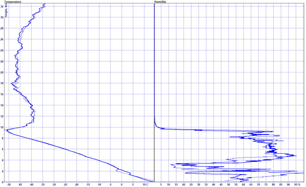
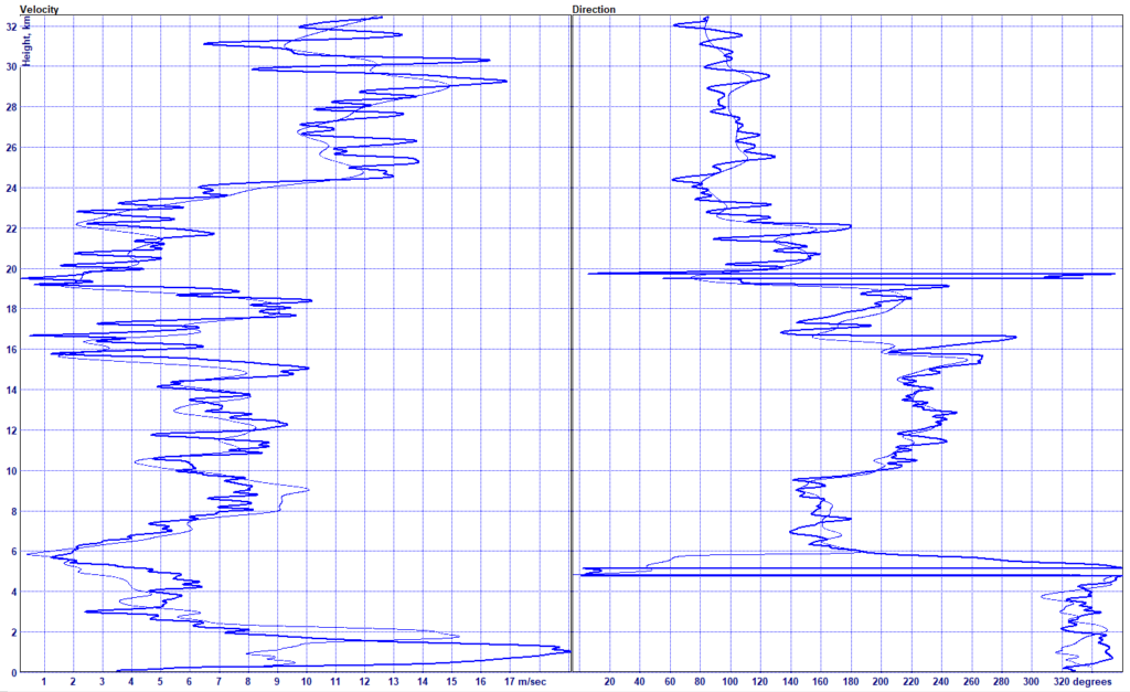
It is interesting to compare the ascent and descent parts of a radiosonde flight. The following graphs show that the descent data has a similar vertical structure to the ascent data. The profiles differ in the details, being recorded 2-3 hours after the initial launch, in a different location. This is an indication that the descent data provides additional information from the atmospheric conditions.

Comparison of temperature and humidity measurement during ascent and descent (thin line)
Comparison of wind speed and direction measurements during ascent and descent (thin line)

Reported in BUFR format

When an ascending sounding is complete, the data is reported in either the BUFR 3’09’052 or 3’09’057 format. A sounding would traditionally end at this point, but when the descent part is also required, the system continues to receive and process the data.

Once the descending sounding is complete, the data will be reported in a similar BUFR sequence 3’09’056 that has been defined specifically to report and disseminate the descent data. The message format has been available in the Vaisala Sounding System MW41 software since version 2.15 and is already sent from a handful of stations in Europe.

Current usage

Radiosonde descent reports have been monitored in the European Centre for Medium-Range Weather Forecasts (ECMWF) system since June 2019, and currently the BUFR data from German upper-air stations is assimilated to the global forecasting model. This is done partly to recover missing data from the lack of aircraft observation during Covid-19.

Initial results show a positive impact as well as station-dependent differences that need more investigation. The reason for the differences is likely linked to the descent rate of falling radiosondes that can be highly varied in the stratosphere. For most flights, the raw descent winds show reduced variability compared to the ascent winds.

Work continues for calculation and data filtering to get the most out of the valuable descent phase measurement data from radiosonde observations. It seems likely that in the near future, reports of descent profiles can contribute to improved analyses and forecasts.

References:
Virtual Event: Using ECMWF’s Forecasts (UEF2020) (1-4 June 2020): Radiosonde descent data: quality and next steps · ECMWF Events (Indico)

Radiosonde descent reports look promising | ECMWF 

This article was first published here.

Previous ArticleTruWeather and Spire announce commercial relationship
Next Article NASA JPL reveals more details on its international SWOT satellite set to survey the world’s water

Read Similar Stories

Opinion

OPINION: Equipping the world with accurate hydrological data

July 24, 20254 Mins Read
Opinion

OPINION: How will AI weather forecasts make maximum impacts for users?

June 10, 20254 Mins Read
Opinion

OPINION: Advancing the monitoring of space weather events

February 26, 20255 Mins Read
Latest News

Researchers investigate links between air pollution, extreme weather and climate

May 1, 2026

China expands MAZU early warning system for developing countries

April 30, 2026

Météo-France begins construction of France’s tallest weather radar tower in Sembadel

April 29, 2026

Receive breaking stories and features in your inbox each week, for free


Enter your email address:


Supplier Spotlights
  • ELDES S.r.l.
Getting in Touch
  • Contact Us / Advertise
  • Meet the Editors
  • Media Pack
  • Free Weekly E-Newsletter
Our Social Channels
  • Facebook
  • LinkedIn
© 2026 UKi Media & Events a division of UKIP Media & Events Ltd
  • Cookie Policy
  • Privacy Policy
  • Terms and Conditions
  • Notice and Takedown Policy

Type above and press Enter to search. Press Esc to cancel.