


Close Menu
Meteorological Technology International
  • News
    • A-E
      • Agriculture
      • Automated Weather Stations
      • Aviation
      • Climate Measurement
      • Data
      • Developing Countries
      • Digital Applications
      • Early Warning Systems
      • Extreme Weather
    • G-P
      • Hydrology
      • Lidar
      • Lightning Detection
      • New Appointments
      • Nowcasting
      • Numerical Weather Prediction
      • Polar Weather
    • R-S
      • Radar
      • Rainfall
      • Remote Sensing
      • Renewable Energy
      • Satellites
      • Solar
      • Space Weather
      • Supercomputers
    • T-Z
      • Training
      • Transport
      • Weather Instruments
      • Wind
      • World Meteorological Organization
      • Meteorological Technology World Expo
  • Features
  • Online Magazines
    • January 2026
    • April 2025
    • January 2025
    • September 2024
    • April 2024
    • Archive Issues
    • Subscribe Free!
  • Opinion
  • Videos
  • Supplier Spotlight
  • Expo
LinkedIn X (Twitter) Facebook
  • Sign-up for Free Weekly E-Newsletter
  • Meet the Editors
  • Contact Us
  • Media Pack
LinkedIn Facebook
Subscribe
Meteorological Technology International
  • News
      • Agriculture
      • Automated Weather Stations
      • Aviation
      • Climate Measurement
      • Data
      • Developing Countries
      • Digital Applications
      • Early Warning Systems
      • Extreme Weather
      • Hydrology
      • Lidar
      • Lightning Detection
      • New Appointments
      • Nowcasting
      • Numerical Weather Prediction
      • Polar Weather
      • Radar
      • Rainfall
      • Remote Sensing
      • Renewable Energy
      • Satellites
      • Solar
      • Space Weather
      • Supercomputers
      • Training
      • Transport
      • Weather Instruments
      • Wind
      • World Meteorological Organization
      • Meteorological Technology World Expo
  • Features
  • Online Magazines
    1. April 2026
    2. January 2026
    3. September 2025
    4. April 2025
    5. January 2025
    6. September 2024
    7. April 2024
    8. January 2024
    9. Archive Issues
    10. Subscribe Free!
    Featured
    May 5, 2026

    In this Issue – April 2026

    By Web TeamMay 5, 2026
    Recent

    In this Issue – April 2026

    May 5, 2026

    In this Issue – January 2026

    November 27, 2025

    In this Issue – September 2025

    August 11, 2025
  • Opinion
  • Videos
  • Supplier Spotlight
  • Expo
Facebook LinkedIn
Subscribe
Meteorological Technology International
Climate Measurement

Sonardyne provides navigation support to BAS GIANT climate mission studying Greenland’s glaciers

Alex PackBy Alex PackJuly 16, 20263 Mins Read
Share LinkedIn Facebook Twitter Email
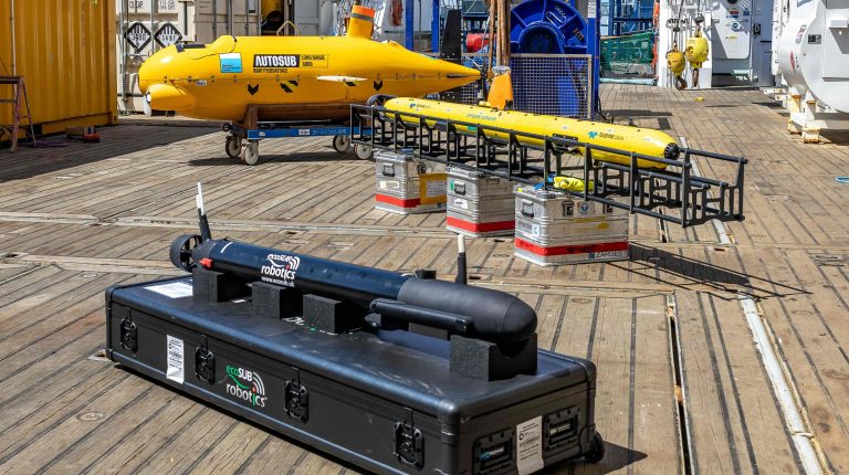
AUVs on the aft deck of the RRS Sir David Attenborough ahead of its GIANT mission. Pictured are Autosub Long Range, a Teledyne Gavia and an ecoSUB Robotics AUV. Credit: Sonardyne.
AUVs on the aft deck of the RRS Sir David Attenborough ahead of its GIANT mission. Pictured are Autosub Long Range, a Teledyne Gavia and an ecoSUB Robotics AUV. Credit: Sonardyne
Share
LinkedIn Facebook Twitter Email

Sonardyne underwater positioning technology is supporting a climate science mission led by the British Antarctic Survey (BAS) that is using autonomous marine robots operating closer to glaciers than had previously been achieved.

The GIANT project is investigating how warming ocean water is causing Greenland’s tidewater glaciers to melt, and what this means for global climate. The UK’s polar research ship RRS Sir David Attenborough will deploy a fleet of aerial, surface and subsea autonomous vehicles as a connected observing system in the Kangerlussuaq Fjord region across July and August this year.

Sonardyne’s Ranger 2 Ultra-Short BaseLine (USBL) positioning system, installed on the RRS Sir David Attenborough, and a Mini-Ranger 2 USBL system on the daughter craft Erebus, will track and control the formation operation of the mission’s underwater vehicles as they map the glacier’s underwater face.

The underwater vehicles include the UK National Oceanography Centre’s Autosub Long Range (also known as Boaty McBoatface), a Teledyne Gavia, and ecoSUB Robotics autonomous underwater vehicles. The mission also involves embedded robotic sensors, a DriX uncrewed surface vessel and aerial drones.

GIANT – which stands for Greenland Ice sheet to AtlaNtic Tipping points from ice loss – involves 15 collaborating institutions and five technology partners, and is backed by the UK’s Advanced Research and Invention Agency (ARIA) as part of its Forecasting Tipping Points program.
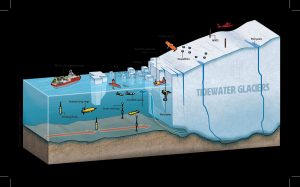
Exploring the dynamic environment of tidewater glaciers using a diverse array of scientific instruments, from research vessels and underwater drones to surface sensors and aerial vehicles. Credit: Ben Gilliland

Dr. Pierre Dutrieux, an oceanographer at BAS leading the ocean robotics research on RRS Sir David Attenborough, said the mission would help address gaps in current climate data.

“This is an exciting and ambitious mission using fleets of autonomous vehicles to help us gather data in otherwise extremely hard to access environments,” Dutrieux said. “The data they collect will help to transform how we forecast ice loss in Greenland’s fjords and improve early warning systems for tipping points that could reshape our planet’s climate.”

Michelle Barnett, business development manager for ocean science at Sonardyne, said the company’s systems provide the positioning layer that keeps the robotic fleet coordinated.

“Our acoustic and inertial systems provide the positioning layer that helps underwater robots know where they are, stay coordinated and return reliable scientific data,” Barnett said. “By helping those robots operate safely and accurately in one of the harshest environments on Earth, Sonardyne is enabling research that could improve climate models and deepen understanding of a critical global challenge.”

Because GPS signals do not function underwater, and visibility in the glacier environment can be near zero, the mission depends on acoustic and inertial navigation to keep multiple vehicles operating safely in formation.

Related news, Windracers ULTRA drones to be deployed in Greenland on glacier surveying mission

Previous ArticleNASA’s SunRISE mission switches to SpaceX Falcon Heavy launch vehicle

Read Similar Stories

Climate Measurement

WMO reports record dust storms in China and USA-Mexico border in 2025

July 13, 20263 Mins Read
Climate Measurement

Copernicus reports hottest June on record for Western Europe

July 9, 20262 Mins Read
Digital Applications

Synoptic Data awarded UK Met Office contract for weather data services

July 8, 20262 Mins Read
Latest News

Sonardyne provides navigation support to BAS GIANT climate mission studying Greenland’s glaciers

July 16, 2026

NASA’s SunRISE mission switches to SpaceX Falcon Heavy launch vehicle

July 15, 2026

More than 2,700 estimated excess deaths in England and Wales during May and June heatwaves

July 14, 2026

Receive breaking stories and features in your inbox each week, for free


Enter your email address:


Supplier Spotlights
  • Baron
Getting in Touch
  • Contact Us / Advertise
  • Meet the Editors
  • Media Pack
  • Free Weekly E-Newsletter
Our Social Channels
  • Facebook
  • LinkedIn
© 2026 UKi Media & Events a division of UKIP Media & Events Ltd
  • Cookie Policy
  • Privacy Policy
  • Terms and Conditions
  • Notice and Takedown Policy

Type above and press Enter to search. Press Esc to cancel.