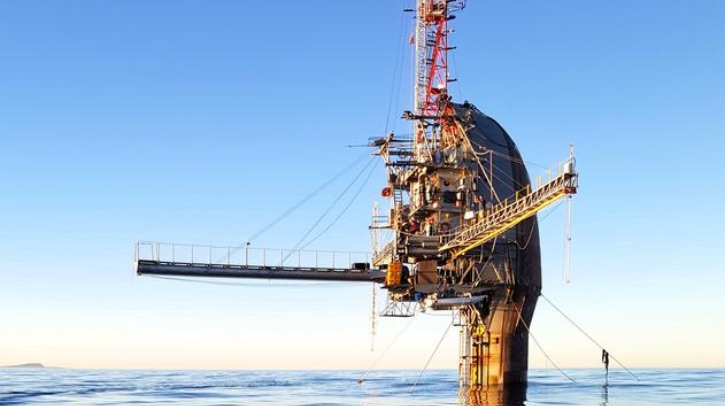
An international team, led by Dr Marc Buckley from the Hereon Institute of Coastal Ocean Dynamics, has used the particle image velocimetry method on board the research platform FLIP (Floating Instrument Platform) in the Pacific Ocean to capture high-resolution images of airflow just a few millimeters to 1m above the ocean surface. According to the team, this marks the first time the technique has been used over the open ocean.
Particle image velocimetry for the open ocean
The imagery is based on a laser that passes through both air and water. The green beam hits water droplets introduced into the air – similar to mist illuminated by sunlight. These droplets follow the motion of the airflow, scatter the laser light and make even the smallest movements in the air visible. At the same time, the laser penetrates the water surface. At the wind-driven surface, the light is refracted – revealing the structure of the water surface. This combination enables both the air and water sides to be visualized. The method is based on particle image velocimetry (PIV), a technique in fluid dynamics that provides precise information about flow structure and wind speeds.
High-resolution imagery findings
The researchers were able to identify two wind-wave coupling mechanisms that occur simultaneously but act differently. They found that short waves, about 1m in length, move slower than the wind, which causes a separation of the airflow. The wave crest blocks the wind, creating a pressure difference that transfers energy to the wave. Long waves, on the other hand – up to 100m in length – were found to move faster than the wind and generate different airflow patterns through their motion. These mechanisms operate simultaneously in different parts of the wave field.
This insight is said to be crucial for advancing atmospheric and oceanic models. The research team plans to further develop the system to also capture movements below the water surface with greater precision.
“Until now, no one has measured the airflow this close to the ocean surface, let alone mapped the mechanisms of energy exchange at such a fine scale,” said lead author Buckley. “Our observations shed light on a physical frontier. This will enable us to advance the theoretical framework and develop more accurate descriptions of air-sea exchange processes, which have so far been only partially understood.”
In related news, researchers from Nanjing Tech University and the Chinese Academy of Sciences recently introduced a model called CNN-SENet, designed to deliver more accurate and computationally efficient wind speed retrievals across global oceans. The study has been published in Satellite Navigation. Read the full story here


