


Contrails are one of aviation’s most visible non-CO2 effects, yet for many years they were treated primarily as a scientific concern rather than an operational variable. That divide is beginning to narrow. As airlines, avionics specialists and climate modeling partners refine their understanding of how persistent contrails form, attention has shifted toward whether targeted changes in flight planning can reduce climate impact without disrupting schedules. A joint initiative involving Amelia and Thales illustrates how contrail avoidance can evolve from trial activity into standard operational practice and help reaching the net-zero objective for air transportation by 2050.
From trials to routine deployment
Rather than relying on isolated trials or academic simulations, the work of Amelia and Thales has focused on decision support integrated into flight planning workflows, with the intent of making contrail mitigation usable by operational teams. The main challenge is that contrail occurrence is uneven. Only a minority of flights encounter conditions conducive to long-lived contrail cirrus, and uncertainty in forecasting and quantifying contrail impact has often been cited as a barrier to operational adoption. Amelia and Thales’ strategy, within the framework of the French DECOR project, has been to concentrate efforts on rarer, higher-impact situations rather than applying broad, indiscriminate changes, as 3% of the “big hits” may be responsible for 80% of the warming effect.
Simple lever: modest altitude adjustments
The initiative began in 2024 on services between Paris, France, and Valladolid, Spain, where altitude-based adjustments were tested in live operations. The focus was on whether modest vertical changes could reduce contrail formation while remaining compatible with air traffic management constraints. The underlying logic is operationally attractive: adjusting altitude is typically easier to assess and file than redesigning lateral routes, especially on short and medium haul services operating in constrained airspace. As confidence grew, the work progressed toward broader operational use. In 2025, in accordance with the companies’ climate impact estimation models, the solution was deployed across eligible Amelia flights
The role of verification using all-sky imagers
The reported outcomes underline the project’s selective nature. Over the course of 2025, the companies stated that only 59 flights were modified out of more than 6,400 operated during the year, yet these changes accounted for the avoidance of more than 2,000 tons of CO2 equivalent emissions and a reduction of over 65% in average climate impact per affected flight. The companies also reported that the total impact of these changes remained below 0.1% additional fuel consumption across the annual total of the affected flights. Our conclusion is the following: selectivity is not a comms operation, but a response to technical reality by focusing on flights expected to produce the largest warming effect. The approach limits exposure to modeling uncertainty while keeping the operational footprint small.
Operational realism is central to the concept. Alternative profiles are evaluated not only for contrail-avoidance potential, but also for fuel burn, time penalties and compatibility with air traffic constraints. In most cases, the mitigation strategy is described as requiring modest changes, such as altering cruise altitude by a few thousand feet over limited route segments, rather than introducing broad re-routings.
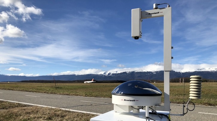
Verification has emerged as a critical element in building confidence. Predictive models carry uncertainty, and airlines and regulators require evidence that proposed avoidance measures deliver real atmospheric benefits. In the Amelia and Thales project, the companies reported that results were analyzed by the climate startup Klima and verified through occasional ground observations, using the SII contrail tracker visualisation platform. Validation was reported to include spot checks using Reuniwatt’s ground-based imagers, linking predicted avoidance to observed contrail outcomes on Amelia flights and nearby traffic.
Some challenges remain: airspace congestion can limit the flexibility available for trajectory optimization, and the benefits of contrail avoidance are not uniform across regions, seasons, and day or night operations. In addition, regulatory frameworks have not yet incorporated non-CO2 effects into standard performance metrics. Wider adoption would require coordination across operators and air navigation stakeholders. However, the project suggests that the operational barriers are lower than once assumed when solutions are integrated into workflows and backed by credible validation.
Operational practice for contrails observations
Measurements must be part of the enabling infrastructure. Reuniwatt’s role in this ecosystem centers on long wave infrared all-sky imagers designed for continuous observation of the full-sky dome, deployed at strategic locations, supporting the detection and tracking of contrails from early formation, providing information that cannot be obtained using satellites. In contrail avoidance programs, this ground-based perspective can provide an independent verification layer by comparing predicted outcomes with observed conditions over a defined area and time window, helping operators and technology providers identify where forecasting performs well and where further refinement is needed.
More broadly for aviation, Reuniwatt positions its all-sky imaging and associated data services as tools for contrails observations and validation, and for airport weather monitoring applications that support air traffic activities. For airlines and aviation stakeholders assessing next steps on non–CO2 mitigation, the project offers a concrete example of how operational decisions and atmospheric science can be brought together.
Readers interested in discussing contrail observation and validation can join the free upcoming webinar “CONTRAILS, Climate, and AI-Driven Observation: Research Insights and Future Directions” with speakers from Reuniwatt, Thales and LATMOS. Click here to register .

Authors
Dr Laurent Sauvage worked formerly at CNRS/IPSL as a researcher on cirrus and contrails observations using lidars and satellites. He has been co-PI for France at major European research institutions for aerosols and clouds ground observations. Sauvage is now advising Reuniwatt in its ground-based imagers development for climate and ATM-related segments. Reuniwatt is involved in various research projects related to contrails climate mitigaton, as E-Contrails 2 and other SESAR projects.

Hannah Bergler is a freelance marketing, communications and business development expert and has been working with Reuniwatt since 2019, where she manages communications and a multilingual webinar series focused on meteorology, atmospheric sciences and renewable energy applications. She has studied physics, and began her career in the solar sector in 2010 at Siemens PV. Since 2013, she has worked as an independent consultant and journalist for international clients, with a focus on renewable energy, as well as weather intelligence.