


Close Menu
Meteorological Technology International
  • News
    • A-E
      • Agriculture
      • Automated Weather Stations
      • Aviation
      • Climate Measurement
      • Data
      • Developing Countries
      • Digital Applications
      • Early Warning Systems
      • Extreme Weather
    • G-P
      • Hydrology
      • Lidar
      • Lightning Detection
      • New Appointments
      • Nowcasting
      • Numerical Weather Prediction
      • Polar Weather
    • R-S
      • Radar
      • Rainfall
      • Remote Sensing
      • Renewable Energy
      • Satellites
      • Solar
      • Space Weather
      • Supercomputers
    • T-Z
      • Training
      • Transport
      • Weather Instruments
      • Wind
      • World Meteorological Organization
      • Meteorological Technology World Expo
  • Features
  • Online Magazines
    • January 2026
    • April 2025
    • January 2025
    • September 2024
    • April 2024
    • Archive Issues
    • Subscribe Free!
  • Opinion
  • Videos
  • Supplier Spotlight
  • Expo
LinkedIn X (Twitter) Facebook
  • Sign-up for Free Weekly E-Newsletter
  • Meet the Editors
  • Contact Us
  • Media Pack
LinkedIn Facebook
Subscribe
Meteorological Technology International
  • News
      • Agriculture
      • Automated Weather Stations
      • Aviation
      • Climate Measurement
      • Data
      • Developing Countries
      • Digital Applications
      • Early Warning Systems
      • Extreme Weather
      • Hydrology
      • Lidar
      • Lightning Detection
      • New Appointments
      • Nowcasting
      • Numerical Weather Prediction
      • Polar Weather
      • Radar
      • Rainfall
      • Remote Sensing
      • Renewable Energy
      • Satellites
      • Solar
      • Space Weather
      • Supercomputers
      • Training
      • Transport
      • Weather Instruments
      • Wind
      • World Meteorological Organization
      • Meteorological Technology World Expo
  • Features
  • Online Magazines
    1. April 2026
    2. January 2026
    3. September 2025
    4. April 2025
    5. January 2025
    6. September 2024
    7. April 2024
    8. January 2024
    9. Archive Issues
    10. Subscribe Free!
    Featured
    May 5, 2026

    In this Issue – April 2026

    By Web TeamMay 5, 2026
    Recent

    In this Issue – April 2026

    May 5, 2026

    In this Issue – January 2026

    November 27, 2025

    In this Issue – September 2025

    August 11, 2025
  • Opinion
  • Videos
  • Supplier Spotlight
  • Expo
Facebook LinkedIn
Subscribe
Meteorological Technology International
Digital Applications

NWS launches website for water forecast services and flood inundation maps

Elizabeth BakerBy Elizabeth BakerJanuary 16, 20242 Mins Read
Share LinkedIn Facebook Twitter Email
Share
LinkedIn Facebook Twitter Email

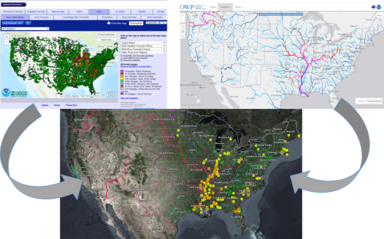
NOAA’s National Weather Service (NWS) has unveiled an experimental website, called the National Water Prediction Service, as the gateway to the agency’s water data and forecast information.

According to the organization, the new site is mobile-friendly, modern and efficient with an intuitive and flexible infrastructure, enabling users to make sound decisions when it comes to water. It centralizes data from the Advanced Hydrologic Prediction Service and the Office of Water Prediction.

One of the products on the Advanced Hydrologic Prediction Service being updated on the National Water Prediction Service is hydrographs. Hydrographs visually show water level observations and forecasts in a single graphic. When a gauge along a river experiences heavy rainfall and is forecast to rise above the flood stage, National Weather Service hydrologists and personnel can relay this information to emergency managers and the public. These new hydrographs show observations over the past 30 days, compared with only 72 hours on the old website. River flood forecasts will continue to look ahead up to seven days in advance.
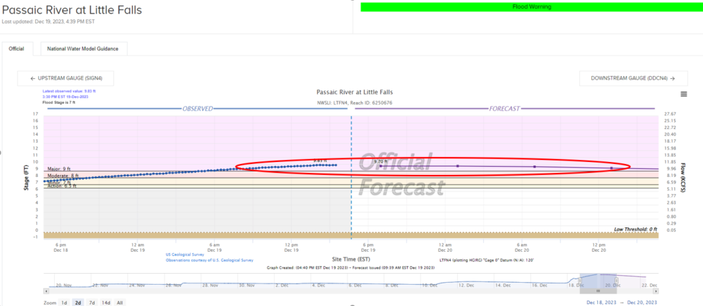
This entire range of observations and the upcoming forecast are adjustable to a timeframe suitable for people who need this data, such as emergency managers. The hydrographs include other information, such as gauge location, historical crests, photos and FEMA National Flood Hazard Layers.

The National Water Prediction Service also features a layering and map option with the ability to view current watches, warnings and advisories; the National Water Model, which offers guidance to ungauged areas of streams and creeks across the country for the first time; flood inundation mapping services that currently cover 10% of the USA; and a mobile capability with downloadable GIS data available.

For more key digital applications updates from the meteorological technology industry, click here.

Previous ArticleECMWF launches four-year project to intensify use of ML in weather prediction
Next Article Vaisala launches weather confidence platform for short-term forecast accuracy

Read Similar Stories

Artificial Intelligence

Machine learning opens new possibilities for global atmospheric reanalysis

July 22, 20263 Mins Read
Artificial Intelligence

Met Office and Alan Turing Institute research shows AI can produce physically realistic weather forecasts

July 10, 20263 Mins Read
Digital Applications

Synoptic Data awarded UK Met Office contract for weather data services

July 8, 20262 Mins Read
Latest News

Machine learning opens new possibilities for global atmospheric reanalysis

July 22, 2026

North Sea marine heatwave intensified impacts of Storm Babet by 9-20%

July 21, 2026

FEATURE: UAH study tracks post-wildfire weather shifts

July 21, 2026

Receive breaking stories and features in your inbox each week, for free


Enter your email address:


Supplier Spotlights
  • Meteomatics AG
Getting in Touch
  • Contact Us / Advertise
  • Meet the Editors
  • Media Pack
  • Free Weekly E-Newsletter
Our Social Channels
  • Facebook
  • LinkedIn
© 2026 UKi Media & Events a division of UKIP Media & Events Ltd
  • Cookie Policy
  • Privacy Policy
  • Terms and Conditions
  • Notice and Takedown Policy

Type above and press Enter to search. Press Esc to cancel.