


Close Menu
Meteorological Technology International
  • News
    • A-E
      • Agriculture
      • Automated Weather Stations
      • Aviation
      • Climate Measurement
      • Data
      • Developing Countries
      • Digital Applications
      • Early Warning Systems
      • Extreme Weather
    • G-P
      • Hydrology
      • Lidar
      • Lightning Detection
      • New Appointments
      • Nowcasting
      • Numerical Weather Prediction
      • Polar Weather
    • R-S
      • Radar
      • Rainfall
      • Remote Sensing
      • Renewable Energy
      • Satellites
      • Solar
      • Space Weather
      • Supercomputers
    • T-Z
      • Training
      • Transport
      • Weather Instruments
      • Wind
      • World Meteorological Organization
      • Meteorological Technology World Expo
  • Features
  • Online Magazines
    • January 2026
    • April 2025
    • January 2025
    • September 2024
    • April 2024
    • Archive Issues
    • Subscribe Free!
  • Opinion
  • Videos
  • Supplier Spotlight
  • Expo
LinkedIn X (Twitter) Facebook
  • Sign-up for Free Weekly E-Newsletter
  • Meet the Editors
  • Contact Us
  • Media Pack
LinkedIn Facebook
Subscribe
Meteorological Technology International
  • News
      • Agriculture
      • Automated Weather Stations
      • Aviation
      • Climate Measurement
      • Data
      • Developing Countries
      • Digital Applications
      • Early Warning Systems
      • Extreme Weather
      • Hydrology
      • Lidar
      • Lightning Detection
      • New Appointments
      • Nowcasting
      • Numerical Weather Prediction
      • Polar Weather
      • Radar
      • Rainfall
      • Remote Sensing
      • Renewable Energy
      • Satellites
      • Solar
      • Space Weather
      • Supercomputers
      • Training
      • Transport
      • Weather Instruments
      • Wind
      • World Meteorological Organization
      • Meteorological Technology World Expo
  • Features
  • Online Magazines
    1. April 2026
    2. January 2026
    3. September 2025
    4. April 2025
    5. January 2025
    6. September 2024
    7. April 2024
    8. January 2024
    9. Archive Issues
    10. Subscribe Free!
    Featured
    May 5, 2026

    In this Issue – April 2026

    By Web TeamMay 5, 2026
    Recent

    In this Issue – April 2026

    May 5, 2026

    In this Issue – January 2026

    November 27, 2025

    In this Issue – September 2025

    August 11, 2025
  • Opinion
  • Videos
  • Supplier Spotlight
  • Expo
Facebook LinkedIn
Subscribe
Meteorological Technology International
Lidar

Leosphere launches dual scanning lidar offering for wind measurement

Helen NormanBy Helen NormanJune 4, 20212 Mins Read
Share LinkedIn Facebook Twitter Email
Wind scan
Share
LinkedIn Facebook Twitter Email

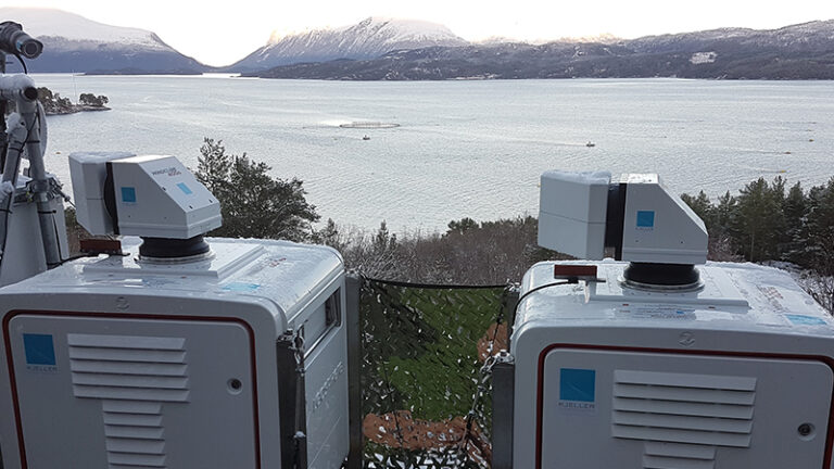
Leosphere has announced the launch of its new WindCube Scan Dual Lidar Ready offering. According to the company, the new offering enables offshore wind project developers and operators to reduce multiple sources of uncertainty and gain a more comprehensive picture of wind resource profiles by observing an offshore location from several positions.

“As the utilization of offshore wind energy continues its massive growth in regions around the globe, projects are evolving to include larger turbines, increased heights and denser installations,” said Matthieu Boquet, head of products, wind energy at Leosphere, a Vaisala company that specializes in developing, manufacturing and servicing turnkey wind lidar instruments for wind energy.

“By simultaneously providing complete, spatial wind data from several strategically selected positions, this new offering supports the offshore evolution by significantly increasing the quantity and dramatically improving the quality of wind data in a cost-efficient way,” he added.

Utilizing two WindCube Scan devices located on the shore or on offshore platforms, this approach delivers wind mapping with typical ranges up to 10km from several positions at once. The solution leverages intersecting beams for better coverage and accuracy, reducing vertical and horizontal uncertainty, and enabling fine assessment of turbulence intensity for turbine suitability. According to Leosphere, the result is a richer understanding of nearshore wind resources, improved reliability, and great campaign cost-effectiveness.

“With its multiple benefits and advanced operational track record, dual scanning lidar is gaining significant traction in the offshore wind market,” said Bastian Schmidt, team leader of remote sensing at DNV. “At DNV, we are strengthening confidence in supporting such a solution for projects in challenging nearshore and offshore environments due to the technology’s increasing maturity and industry acceptance.”

Previous ArticleSaildrone to launch fleet of ocean drones to gather crucial data on 2021 hurricane season
Next Article Climavision receives US$100m investment for growth of high-resolution weather platform

Read Similar Stories

Weather Instruments

FT Technologies’ wind sensor deployed in storm-chasing research

February 11, 20263 Mins Read
Lidar

DNV completes IEC classification of ZX 300e wind lidar

February 6, 20262 Mins Read
Automated Weather Stations

Vaisala unveils Elements Lite software for real-time, customizable weather insights

October 14, 20252 Mins Read
Latest News

SMILE mission launches to study Earth’s magnetic shield and space weather

May 20, 2026

Cloud measurement campaign targets improved climate model accuracy

May 20, 2026

VIDEO: Meteosat-12 imagery over Europe and Africa made available via YouTube streams

May 19, 2026

Receive breaking stories and features in your inbox each week, for free


Enter your email address:


Supplier Spotlights
  • Synoptic Data PBC
Getting in Touch
  • Contact Us / Advertise
  • Meet the Editors
  • Media Pack
  • Free Weekly E-Newsletter
Our Social Channels
  • Facebook
  • LinkedIn
© 2026 UKi Media & Events a division of UKIP Media & Events Ltd
  • Cookie Policy
  • Privacy Policy
  • Terms and Conditions
  • Notice and Takedown Policy

Type above and press Enter to search. Press Esc to cancel.