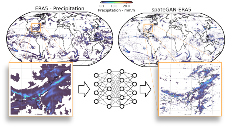
Researchers at the Karlsruhe Institute of Technology (KIT) have developed a model that uses artificial intelligence (AI) to convert low-resolution global weather data into high-resolution precipitation maps. Their findings have been published in npj Climate and Atmospheric Science.
Combining historical data and AI
“Heavy rainfall and flooding are much more common in many regions of the world than they were just a few decades ago,” said Dr Christian Chwala, an expert on hydrometeorology and machine learning at the Institute of Meteorology and Climate Research (IMK-IFU) on KIT’s Campus Alpin in the German town of Garmisch-Partenkirchen. “But until now, the data needed for reliable regional assessments of such extreme events was missing for many locations.” His research team addressed this problem with a new AI that can generate precise global precipitation maps from low-resolution information. The result is a unique tool for the analysis and assessment of extreme weather, even for regions with poor data coverage, such as the Global South.
For the method, the researchers use historical data from weather models that describe global precipitation at hourly intervals with a spatial resolution of about 24km. Not only was their generative AI model (spateGEN-ERA5) trained with this data, but it also learned (from high-resolution weather radar measurements made in Germany) how precipitation patterns and extreme events correlate at different scales, from coarse to fine.
“Our AI model doesn’t merely create a more sharply focused version of the input data, it generates multiple physically plausible, high-resolution precipitation maps,” said Luca Glawion, one of the researchers at IMK-IFU, who developed the model while working on his doctoral thesis in the SCENIC research project. “Details at a resolution of 2km and 10 minutes become visible. The model also provides information about the statistical uncertainty of the results, which is especially relevant when modeling regionalized heavy rainfall events.” He also noted that validation with weather radar data from the US and Australia showed that the method can be applied to entirely different climatic conditions.
Assessing flood risks worldwide
Due to the method’s global applicability, the researchers hope to offer new possibilities for better assessment of regional climate risks. “It’s the especially vulnerable regions that often lack the resources for detailed weather observations,” said Dr Julius Polz of IMK-IFU, who was also involved in the model’s development. “Our approach will enable us to make much more reliable assessments of where heavy rainfall and floods are likely to occur, even in such regions with poor data coverage.” Not only can the new AI method contribute to disaster control in emergencies, but it can also help with the implementation of more effective long-term preventive measures, such as flood control.
In related news, Will Downs, a PhD student at the University of Miami Rosenstiel School of Marine, Atmospheric and Earth Science, recently created an AI model that identifies and tracks tropical easterly waves that can develop into powerful hurricanes as they travel across the Atlantic Ocean. Click here to read the full story.


