


Close Menu
Meteorological Technology International
  • News
    • A-E
      • Agriculture
      • Automated Weather Stations
      • Aviation
      • Climate Measurement
      • Data
      • Developing Countries
      • Digital Applications
      • Early Warning Systems
      • Extreme Weather
    • G-P
      • Hydrology
      • Lidar
      • Lightning Detection
      • New Appointments
      • Nowcasting
      • Numerical Weather Prediction
      • Polar Weather
    • R-S
      • Radar
      • Rainfall
      • Remote Sensing
      • Renewable Energy
      • Satellites
      • Solar
      • Space Weather
      • Supercomputers
    • T-Z
      • Training
      • Transport
      • Weather Instruments
      • Wind
      • World Meteorological Organization
      • Meteorological Technology World Expo
  • Features
  • Online Magazines
    • January 2026
    • April 2025
    • January 2025
    • September 2024
    • April 2024
    • Archive Issues
    • Subscribe Free!
  • Opinion
  • Videos
  • Supplier Spotlight
  • Expo
LinkedIn X (Twitter) Facebook
  • Sign-up for Free Weekly E-Newsletter
  • Meet the Editors
  • Contact Us
  • Media Pack
LinkedIn Facebook
Subscribe
Meteorological Technology International
  • News
      • Agriculture
      • Automated Weather Stations
      • Aviation
      • Climate Measurement
      • Data
      • Developing Countries
      • Digital Applications
      • Early Warning Systems
      • Extreme Weather
      • Hydrology
      • Lidar
      • Lightning Detection
      • New Appointments
      • Nowcasting
      • Numerical Weather Prediction
      • Polar Weather
      • Radar
      • Rainfall
      • Remote Sensing
      • Renewable Energy
      • Satellites
      • Solar
      • Space Weather
      • Supercomputers
      • Training
      • Transport
      • Weather Instruments
      • Wind
      • World Meteorological Organization
      • Meteorological Technology World Expo
  • Features
  • Online Magazines
    1. April 2026
    2. January 2026
    3. September 2025
    4. April 2025
    5. January 2025
    6. September 2024
    7. April 2024
    8. January 2024
    9. Archive Issues
    10. Subscribe Free!
    Featured
    May 5, 2026

    In this Issue – April 2026

    By Web TeamMay 5, 2026
    Recent

    In this Issue – April 2026

    May 5, 2026

    In this Issue – January 2026

    November 27, 2025

    In this Issue – September 2025

    August 11, 2025
  • Opinion
  • Videos
  • Supplier Spotlight
  • Expo
Facebook LinkedIn
Subscribe
Meteorological Technology International
Satellites

NOAA satellites helped rescue nearly 400 people in the US in 2022

Dan SymondsBy Dan SymondsJanuary 25, 20232 Mins Read
Share LinkedIn Facebook Twitter Email
Photo credit: NOAA
Share
LinkedIn Facebook Twitter Email

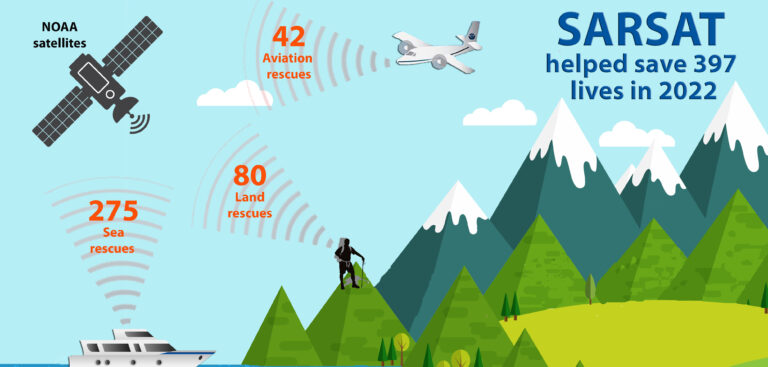
Meteorological satellites used by the US National Oceanic and Atmospheric Administration (NOAA) helped rescue 397 people from potentially life-threatening situations in 2022.

NOAA’s polar-orbiting and geostationary satellites are part of the global Search and Rescue Satellite Aided Tracking (COSPAS-SARSAT) system, which uses a network of US and international spacecraft to detect and locate distress signals sent from emergency beacons on aircraft, boats and handheld personal locator beacons (PLBs) anywhere in the world.

Of the 397 US rescues last year, 275 were water rescues, 42 were from downed aircraft and 80 were on land involving PLBs. Florida had the most SARSAT rescues with 106, followed by Alaska with 56 and Utah with 20.

Since its start in 1982, COSPAS-SARSAT has been credited with supporting more than 50,000 rescues worldwide, including more than 10,100 in the US and its surrounding waters.

When an NOAA satellite pinpoints the location of a distress signal in the US, the information is relayed to the SARSAT Mission Control Center at NOAA’s Satellite Operations Facility in Suitland, Maryland. From there, the information is sent quickly to Rescue Coordination Centers, operated by the US Air Force for land rescues and the US Coast Guard for water rescues. NOAA also supports rescues globally by relaying distress signal information to international SARSAT partners.

Steve Volz, assistant administrator for NOAA’s Satellite and Information Service, said, “The value of NOAA satellites goes well beyond forecasting. The life-saving ability of SARSAT is a credit to the teamwork with the US Coast Guard, the US Air Force, NASA and our international partners.

“In keeping with its mission, the SARSAT program truly takes the ‘search’ out of search and rescue.”

Previous Article‘Self-cleaning’ processes in the marine atmosphere are better than expected, finds study
Next Article ECMWF prototype for monitoring anthropogenic CO2 emissions nears completion

Read Similar Stories

Satellites

SMILE mission launches to study Earth’s magnetic shield and space weather

May 20, 20263 Mins Read
Videos

VIDEO: Meteosat-12 imagery over Europe and Africa made available via YouTube streams

May 19, 20262 Mins Read
Extreme Weather

Wildfires can create ‘burn scar heat islands’ that alter weather patterns, study finds

May 6, 20263 Mins Read
Latest News

R.M. Young Company reengineers SNOdar snow-depth sensor

May 21, 2026

SMILE mission launches to study Earth’s magnetic shield and space weather

May 20, 2026

Cloud measurement campaign targets improved climate model accuracy

May 20, 2026

Receive breaking stories and features in your inbox each week, for free


Enter your email address:


Supplier Spotlights
  • GAMIC GmbH
Getting in Touch
  • Contact Us / Advertise
  • Meet the Editors
  • Media Pack
  • Free Weekly E-Newsletter
Our Social Channels
  • Facebook
  • LinkedIn
© 2026 UKi Media & Events a division of UKIP Media & Events Ltd
  • Cookie Policy
  • Privacy Policy
  • Terms and Conditions
  • Notice and Takedown Policy

Type above and press Enter to search. Press Esc to cancel.