Close Menu
Meteorological Technology International
  • News
    • A-E
      • Agriculture
      • Automated Weather Stations
      • Aviation
      • Climate Measurement
      • Data
      • Developing Countries
      • Digital Applications
      • Early Warning Systems
      • Extreme Weather
    • G-P
      • Hydrology
      • Lidar
      • Lightning Detection
      • New Appointments
      • Nowcasting
      • Numerical Weather Prediction
      • Polar Weather
    • R-S
      • Radar
      • Rainfall
      • Remote Sensing
      • Renewable Energy
      • Satellites
      • Solar
      • Space Weather
      • Supercomputers
    • T-Z
      • Training
      • Transport
      • Weather Instruments
      • Wind
      • World Meteorological Organization
      • Meteorological Technology World Expo
  • Features
  • Online Magazines
    • January 2026
    • April 2025
    • January 2025
    • September 2024
    • April 2024
    • Archive Issues
    • Subscribe Free!
  • Opinion
  • Videos
  • Supplier Spotlight
  • Expo
LinkedIn X (Twitter) Facebook
  • Sign-up for Free Weekly E-Newsletter
  • Meet the Editors
  • Contact Us
  • Media Pack
LinkedIn Facebook
Subscribe
Meteorological Technology International
  • News
      • Agriculture
      • Automated Weather Stations
      • Aviation
      • Climate Measurement
      • Data
      • Developing Countries
      • Digital Applications
      • Early Warning Systems
      • Extreme Weather
      • Hydrology
      • Lidar
      • Lightning Detection
      • New Appointments
      • Nowcasting
      • Numerical Weather Prediction
      • Polar Weather
      • Radar
      • Rainfall
      • Remote Sensing
      • Renewable Energy
      • Satellites
      • Solar
      • Space Weather
      • Supercomputers
      • Training
      • Transport
      • Weather Instruments
      • Wind
      • World Meteorological Organization
      • Meteorological Technology World Expo
  • Features
  • Online Magazines
    1. January 2026
    2. September 2025
    3. April 2025
    4. January 2025
    5. September 2024
    6. April 2024
    7. January 2024
    8. September 2023
    9. April 2023
    10. Archive Issues
    11. Subscribe Free!
    Featured
    November 27, 2025

    In this Issue – January 2026

    By Hazel KingNovember 27, 2025
    Recent

    In this Issue – January 2026

    November 27, 2025

    In this Issue – September 2025

    August 11, 2025

    In this Issue – April 2025

    April 15, 2025
  • Opinion
  • Videos
  • Supplier Spotlight
  • Expo
Facebook LinkedIn
Subscribe
Meteorological Technology International
Extreme Weather

Satellite images reveal cause of Chamoli disaster to be rock and ice avalanche

Helen NormanBy Helen NormanJune 15, 20213 Mins Read
Share LinkedIn Facebook Twitter Email
Sentinel-2. Image ESA/ATG medialab
Share
LinkedIn Facebook Twitter Email

A new study using satellite evidence has confirmed that a rock and ice avalanche caused the Chamoli disaster in India in February 2021. The avalanche killed more than 200 people and destroyed two major hydropower facilities that were under construction.

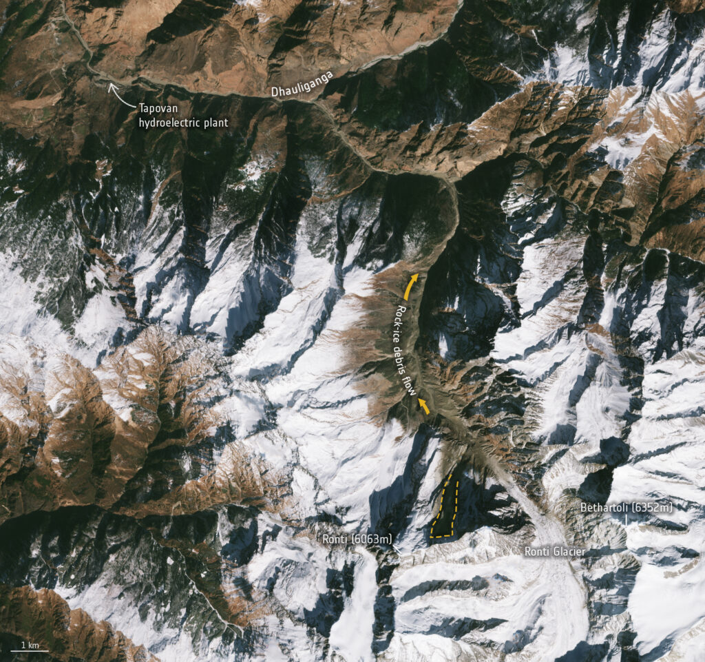
The humanitarian tragedy was the result of around 27 million cubic meters of rock and ice hitting the Chamoli district in the Uttarakhand region of India after it had been released from the steep mountain flank of Ronti Peak.

In response to the disaster, the International Charter: Space and Major Disasters – a venture between 17 space agencies to provide free satellite data to those affected by natural and human-made emergencies – was activated.

The service provides free access to very high-resolution satellite data such as from Worldview 1/2, Cartosat-1 and Pleiades. Combined with freely available images from Landsat and the Copernicus Sentinel-2 mission, scientists analyzed numerous images acquired before and after the event to quantify key measures of the event, such as its total volume, elevation differences and travel distances.

A team of 53 scientists and experts came together to reconstruct the event and investigate the scope and impact of the flood caused by the landslide. Their study, published on June 10 in the journal Science, analyzed satellite imagery, seismic records and eye-witness videos to determine the timing of the event and produce computer models of the flow.

This analysis allowed scientists to discover that the disaster was caused by a large mass of ice and rock dislodged from the slopes of Ronti Peak, starting as a giant landslide that transformed into a mud and debris flow, causing destruction along its path.

The results of the analysis were also sent to the governmental agencies of India to help them plan and support emergency assistance to the local teams.

Chamoli disaster
This Copernicus Sentinel-2 image shows the aftermath of the Chamoli disaster on February 7, 2021. The dotted orange line shows the site of the collapse from the north slope of Ronti Peak. The image contains modified Copernicus Sentinel data (2021), processed by ESA, CC BY-SA 3.0 IGO

Two participants from the European Space Agency‘s (ESA) Climate Change Initiative – the Glaciers_cci and Permafrost_cci projects – helped with the retrieval and analysis of satellite images, which included those from Copernicus Sentinel-2, PlanetLab and Corona.

Professor Andreas Kääb from the University of Oslo was able to determine the volume and ice/rock mixing ratios based on his experience with such events from earlier studies. He explained, “The calculated 80% rock in the avalanche completely converted the 20% glacier ice into water over the 3,200m elevation difference from Ronti Peak to the Tapovan hydropower plant. This conversion is largely responsible for the devastating impact of the resulting mud and debris flood wave.”

Previous ArticleVaisala and FMI to deliver turnkey meteorological infrastructure project in Ethiopia
Next Article Spire Global announces relaunch of its Maritime Weather solutions portfolio

Read Similar Stories

Agriculture

Extreme heat posing significant risks to ecosystems and agriculture, FAO-WMO report warns

April 22, 20263 Mins Read
Space Weather

Northumbria University secures £4m to study Earth’s radiation belts

April 16, 20262 Mins Read
Extreme Weather

AI model improves real-time prediction of wildfire spread

April 16, 20263 Mins Read
Latest News

Extreme heat posing significant risks to ecosystems and agriculture, FAO-WMO report warns

April 22, 2026

Atmospheric G2 secures Japan weather forecasting license

April 21, 2026

China completes Antarctic meteorological research mission with Xuelong icebreaker

April 21, 2026

Receive breaking stories and features in your inbox each week, for free


Enter your email address:


Supplier Spotlights
  • Geolux d.o.o.
Getting in Touch
  • Contact Us / Advertise
  • Meet the Editors
  • Media Pack
  • Free Weekly E-Newsletter
Our Social Channels
  • Facebook
  • LinkedIn
© 2026 UKi Media & Events a division of UKIP Media & Events Ltd
  • Cookie Policy
  • Privacy Policy
  • Terms and Conditions
  • Notice and Takedown Policy

Type above and press Enter to search. Press Esc to cancel.