Meteorological Technology International
  • News
    • A-E
      • Agriculture
      • Automated Weather Stations
      • Aviation
      • Climate Measurement
      • Data
      • Developing Countries
      • Digital Applications
      • Early Warning Systems
      • Extreme Weather
    • G-P
      • Hydrology
      • Lidar
      • Lightning Detection
      • New Appointments
      • Nowcasting
      • Numerical Weather Prediction
      • Polar Weather
    • R-S
      • Radar
      • Rainfall
      • Remote Sensing
      • Renewable Energy
      • Satellites
      • Solar
      • Space Weather
      • Supercomputers
    • T-Z
      • Training
      • Transport
      • Weather Instruments
      • Wind
      • World Meteorological Organization
      • Meteorological Technology World Expo
  • Features
  • Online Magazines
    • April 2025
    • January 2025
    • September 2024
    • April 2024
    • Archive Issues
    • Subscribe Free!
  • Opinion
  • Videos
  • Supplier Spotlight
  • Expo
LinkedIn Twitter Facebook
  • Sign-up for Free Weekly E-Newsletter
  • Meet the Editors
  • Contact Us
  • Media Pack
LinkedIn Facebook
Subscribe
Meteorological Technology International
  • News
      • Agriculture
      • Automated Weather Stations
      • Aviation
      • Climate Measurement
      • Data
      • Developing Countries
      • Digital Applications
      • Early Warning Systems
      • Extreme Weather
      • Hydrology
      • Lidar
      • Lightning Detection
      • New Appointments
      • Nowcasting
      • Numerical Weather Prediction
      • Polar Weather
      • Radar
      • Rainfall
      • Remote Sensing
      • Renewable Energy
      • Satellites
      • Solar
      • Space Weather
      • Supercomputers
      • Training
      • Transport
      • Weather Instruments
      • Wind
      • World Meteorological Organization
      • Meteorological Technology World Expo
  • Features
  • Online Magazines
    1. April 2025
    2. January 2025
    3. September 2024
    4. April 2024
    5. January 2024
    6. September 2023
    7. April 2023
    8. Archive Issues
    9. Subscribe Free!
    Featured
    April 15, 2025

    In this Issue – April 2025

    By Web TeamApril 15, 2025
    Recent

    In this Issue – April 2025

    April 15, 2025

    In this Issue – January 2025

    December 13, 2024

    In this Issue – September 2024

    August 8, 2024
  • Opinion
  • Videos
  • Supplier Spotlight
  • Expo
Facebook LinkedIn
Subscribe
Meteorological Technology International
News

NOAA satellites reveal record heat and drought is raising wildfire risk

Helen NormanBy Helen NormanJuly 6, 20214 Mins Read
Share LinkedIn Facebook Twitter Email
Share
LinkedIn Facebook Twitter Email

The western USA has seen record-breaking high temperatures at the end of June and beginning of July as a heat dome, or mass of warm air, blankets the Pacific Northwest.

The extreme heat, coupled with a severe drought this spring and summer in the region, has combined to significantly raise the risk of wildfire from both human and natural hazards, such as lightning.

NOAA-20 and Suomi NPP, part of the Joint Polar Satellite System (JPSS), detect and monitor drought and plant health using observations from their Visible Infrared Imaging Radiometer Suite (VIIRS) instrument. The VIIRS instrument, which views Earth in visible and infrared wavelengths, detects the “greenness” of vegetation, which shows how many plants there are, how leafy they are, and how healthy they are.

Scientists are able to use that data to color code areas on a map where vegetation is stressed based on a scale of zero (most stressed) to 100, due to lack of water and extreme temperatures.

Additionally, the Active Fire Product provides additional information on active thermal anomalies. This information is used to monitor drought and estimate crop yields but can also be used to estimate fire risk around the world.

The data from June 24, 2021 show that western vegetation is extremely stressed, especially compared with June 2020.  Furthermore, between June 25 and 27, the Geostationary Lightning Mapper (GLM), an instrument on NOAA’s geostationary satellites, GOES-16 and GOES-17, observed significant lightning activity across the western USA from summer storms. GLM monitors lightning activity continuously over the Americas and surrounding ocean regions, collecting information such as the frequency, location and extent of lightning discharges to identify intensifying thunderstorms and tropical cyclones.

Lightning from a June 25 thunderstorm in Northern California sparked the Lava Fire, which has quickly grown to 17,591 acres, according to the InciWeb Incident Information System, and is currently 19% contained.

GOES-16 and GOES-17 have kept constant watch over the area from more than 22,300 miles above the Earth’s surface, providing continuous updates on the fire, though at a coarser resolution than the JPSS satellites, which orbit closer to the planet.

The Advanced Baseline Imager (ABI) on these satellites is capable of detecting heat signatures and changes in fire behavior faster and more accurately than previous versions of this sensor, as well as helping predict the motion of fires in real time.

The ABI measures energy at different wavelengths that is either reflected (visible or near infrared) or emitted (infrared) from Earth’s surface. Thus, it is able to measure the size, temperature and radiative power of fires.

For example, the GOES-R fire detection and characterization data product uses both visible and infrared channels to locate fires and learn about their characteristics. Fire Temperature RGB imagery is used to manually locate and monitor fire hot spots, which are shown as red, orange, yellow or white as it grows hotter. This type of imagery is particularly useful to identify new hot spots and the direction those hot spots are moving, especially for fast-growing or newly-formed fires.

Also, GeoColor imagery combines data from multiple channels from the ABI so it looks similar to what we would see with the naked eye, allowing us to easily spot smoke plumes from fires rising into the atmosphere.

Satellite imagery of several of the fires, including the Pack Creek and Bear Fires in Utah and the Telegraph Fire in Arizona, reveals impressive plumes with thick pyrocumulus clouds, which form when there is enough moisture and atmospheric instability over an intense heat source and smoke.

Suomi NPP and NOAA-20 have been able to track the Lava Fire’s changes overnight through the use of the Day-Night Band, which can see weather patterns and environmental events in low-light conditions. Additionally, when passing over twice a day, the VIIRS instrument provides fine-resolution imagery of the fires, which helps to detect smaller and lower-temperature fires, as well as better map the perimeter of larger fires.

Additionally, the satellites collect detailed information about fire intensity. This data helps to predict the height, thickness and movements of wildfire smoke, which can help inform air quality advisories and warnings to protect public health in the area. After a fire, the satellites can provide high-resolution looks at the burn scars, which can help to forecast post-fire weather events like mudslides and debris flows.

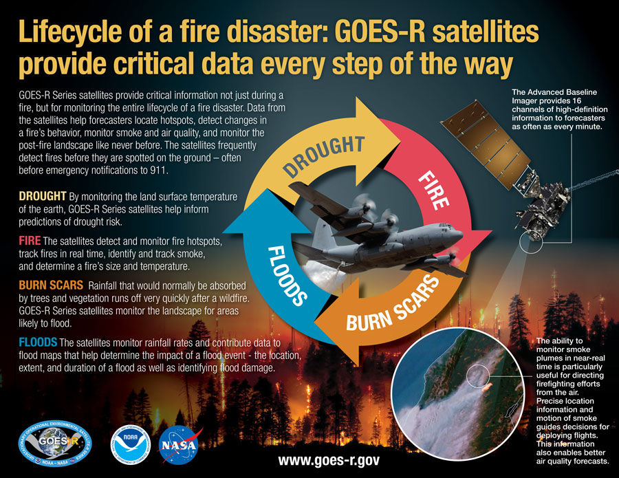
The benefits provided by the latest generation of NOAA satellites aren’t just seen during a fire but are important in monitoring the entire lifecycle of a fire disaster. Data from the satellites are helping forecasters monitor drought conditions, locate hot spots, detect changes in a fire’s behavior, predict a fire’s motion, monitor smoke and air quality, and monitor the post-fire landscape like never before.

Video and story courtesy of: NOAA, NASA Goddard Space Flight Center, CIRA

Previous ArticleEUMETSAT to sign series of cooperation agreements with international agencies
Next Article OTT HydroMet now offering the Aquarius data management platform in Europe

Read Similar Stories

Oceans

VIDEO: NOC satellite data tracks tidal change in Liverpool

May 27, 20253 Mins Read
Numerical Weather Prediction

University of Chicago analyzes AI’s ability to predict unprecedented weather events

May 27, 20255 Mins Read
Climate Measurement

VIDEO: University of Pennsylvania and Microsoft Research develop machine-learning weather prediction model

May 22, 20257 Mins Read
Latest News

WMO releases Global Annual to Decadal Climate Update report

May 30, 2025

OPINION: Atmospheric river research that serves up data rain or shine

May 30, 2025

SOFF Steering Committee moves to mobilize US$200m

May 29, 2025

Receive breaking stories and features in your inbox each week, for free


Enter your email address:


Supplier Spotlights
  • Geolux d.o.o.
Latest Job Postings
  • Postdoctoral researcher position on land surface and vegetation modelling (R2)

    • Barcelona
    • Barcelona Supercomputing Center - Centro Nacional de Supercomputación
    • Full Time
  • HPC Engineer for Earth Sciences applications (RE1/2)

    • Barcelona
    • Barcelona Supercomputing Center - Centro Nacional de Supercomputación
    • Full Time
Getting in Touch
  • Contact Us / Advertise
  • Meet the Editors
  • Download Media Pack
  • Free Weekly E-Newsletter
Our Social Channels
  • Facebook
  • LinkedIn
© 2025 UKi Media & Events a division of UKIP Media & Events Ltd
  • Cookie Policy
  • Privacy Policy
  • Terms and Conditions
  • Notice and Takedown Policy

Type above and press Enter to search. Press Esc to cancel.

We use cookies on our website to give you the most relevant experience by remembering your preferences and repeat visits. By clicking “Accept”, you consent to the use of ALL the cookies.
Cookie settingsACCEPT
Manage consent

Privacy Overview

This website uses cookies to improve your experience while you navigate through the website. Out of these, the cookies that are categorized as necessary are stored on your browser as they are essential for the working of basic functionalities of the ...
Necessary
Always Enabled

Necessary cookies are absolutely essential for the website to function properly. These cookies ensure basic functionalities and security features of the website, anonymously.

CookieDurationDescription
cookielawinfo-checbox-analytics11 monthsThis cookie is set by GDPR Cookie Consent plugin. The cookie is used to store the user consent for the cookies in the category "Analytics".
cookielawinfo-checbox-functional11 monthsThe cookie is set by GDPR cookie consent to record the user consent for the cookies in the category "Functional".
cookielawinfo-checbox-others11 monthsThis cookie is set by GDPR Cookie Consent plugin. The cookie is used to store the user consent for the cookies in the category "Other.
cookielawinfo-checkbox-necessary11 monthsThis cookie is set by GDPR Cookie Consent plugin. The cookies is used to store the user consent for the cookies in the category "Necessary".
cookielawinfo-checkbox-performance11 monthsThis cookie is set by GDPR Cookie Consent plugin. The cookie is used to store the user consent for the cookies in the category "Performance".
viewed_cookie_policy11 monthsThe cookie is set by the GDPR Cookie Consent plugin and is used to store whether or not user has consented to the use of cookies. It does not store any personal data.

Functional

Functional cookies help to perform certain functionalities like sharing the content of the website on social media platforms, collect feedbacks, and other third-party features.

Performance

Performance cookies are used to understand and analyze the key performance indexes of the website which helps in delivering a better user experience for the visitors.

Analytics

Analytical cookies are used to understand how visitors interact with the website. These cookies help provide information on metrics the number of visitors, bounce rate, traffic source, etc.

Advertisement

Advertisement cookies are used to provide visitors with relevant ads and marketing campaigns. These cookies track visitors across websites and collect information to provide customized ads.

Others

Other uncategorized cookies are those that are being analyzed and have not been classified into a category as yet.

SAVE & ACCEPT
Powered by