


The Copernicus Climate Change Service (C3S) has reported that September 2025 was the third-warmest September globally, continuing a persistent trend of exceptional warmth across both land and ocean surfaces.
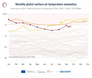
According to data from the ERA5 reanalysis dataset, the global average surface air temperature reached 16.11°C, which is 0.66°C above the 1991-2020 average for September and 1.47°C higher than pre-industrial levels. This makes September 2025 only marginally cooler – by 0.07° – than September 2024, and 0.27°C cooler than the record set in 2023.
“The global temperature in September 2025 was the third warmest on record, nearly as high as in September 2024, less than a tenth of a degree cooler,” said Samantha Burgess, strategic lead for climate at ECMWF. “A year on, the global temperature context remains much the same, with persistently high land and sea surface temperatures reflecting the continuing influence of greenhouse gas accumulation in the atmosphere.”
Regional temperature patterns
Across Europe, average land temperatures were 1.23°C above the 1991–2020 average, making it the fifth-warmest September on record for the continent. The most significant above-average anomalies were observed over Fennoscandia and Eastern Europe, while only parts of Western Europe were slightly cooler than average.
Globally, above-average warmth was particularly pronounced over Canada, Greenland, northwestern Siberia, and large areas of Antarctica, with cooler-than-average conditions limited to northern central Siberia, western Australia, and parts of eastern Antarctica.
Sea surface and sea ice conditions
The global sea surface temperature (SST) averaged 20.72°C, the third-highest for September on record, remaining exceptionally high in the North Pacific and around Northern Europe. ENSO-neutral conditions prevailed, with near- or below-average SSTs in the central and eastern equatorial Pacific.
In the Arctic, daily sea ice extent reached its 14th-lowest annual minimum, and its monthly extent was 12% below the long-term average, while Antarctic daily sea ice extent recorded its third-lowest annual maximum, and the monthly extent was about 5% below average.
Hydrological extremes
September brought wetter-than-average conditions to northwestern and central Europe, Fennoscandia and parts of southern and eastern Europe, with localized flooding. Drier-than-average conditions persisted over the Iberian Peninsula, the Balkans, and parts of Ukraine and western Russia.
Beyond Europe, heavy rainfall and flooding affected regions from the southwestern USA to eastern China, often linked to tropical cyclone activity. Conversely, drought-like conditions persisted in parts of Canada, eastern USA, northern India and northeastern Brazil.
In related news, Study finds climate change may lead to less frequent but more devastating hailstorms in Europe