Close Menu
Meteorological Technology International
  • News
    • A-E
      • Agriculture
      • Automated Weather Stations
      • Aviation
      • Climate Measurement
      • Data
      • Developing Countries
      • Digital Applications
      • Early Warning Systems
      • Extreme Weather
    • G-P
      • Hydrology
      • Lidar
      • Lightning Detection
      • New Appointments
      • Nowcasting
      • Numerical Weather Prediction
      • Polar Weather
    • R-S
      • Radar
      • Rainfall
      • Remote Sensing
      • Renewable Energy
      • Satellites
      • Solar
      • Space Weather
      • Supercomputers
    • T-Z
      • Training
      • Transport
      • Weather Instruments
      • Wind
      • World Meteorological Organization
      • Meteorological Technology World Expo
  • Features
  • Online Magazines
    • January 2026
    • April 2025
    • January 2025
    • September 2024
    • April 2024
    • Archive Issues
    • Subscribe Free!
  • Opinion
  • Videos
  • Supplier Spotlight
  • Expo
LinkedIn X (Twitter) Facebook
  • Sign-up for Free Weekly E-Newsletter
  • Meet the Editors
  • Contact Us
  • Media Pack
LinkedIn Facebook
Subscribe
Meteorological Technology International
  • News
      • Agriculture
      • Automated Weather Stations
      • Aviation
      • Climate Measurement
      • Data
      • Developing Countries
      • Digital Applications
      • Early Warning Systems
      • Extreme Weather
      • Hydrology
      • Lidar
      • Lightning Detection
      • New Appointments
      • Nowcasting
      • Numerical Weather Prediction
      • Polar Weather
      • Radar
      • Rainfall
      • Remote Sensing
      • Renewable Energy
      • Satellites
      • Solar
      • Space Weather
      • Supercomputers
      • Training
      • Transport
      • Weather Instruments
      • Wind
      • World Meteorological Organization
      • Meteorological Technology World Expo
  • Features
  • Online Magazines
    1. January 2026
    2. September 2025
    3. April 2025
    4. January 2025
    5. September 2024
    6. April 2024
    7. January 2024
    8. September 2023
    9. April 2023
    10. Archive Issues
    11. Subscribe Free!
    Featured
    November 27, 2025

    In this Issue – January 2026

    By Hazel KingNovember 27, 2025
    Recent

    In this Issue – January 2026

    November 27, 2025

    In this Issue – September 2025

    August 11, 2025

    In this Issue – April 2025

    April 15, 2025
  • Opinion
  • Videos
  • Supplier Spotlight
  • Expo
Facebook LinkedIn
Subscribe
Meteorological Technology International
News

First images from NASA’s TEMPO mission

William AtkinsonBy William AtkinsonAugust 29, 20233 Mins Read
Share LinkedIn Facebook Twitter Email
Share
LinkedIn Facebook Twitter Email

NASA launched its TEMPO mission into space earlier this year and has now released the first data maps from the new instrument, showing information about major air pollutants over North America.

From its orbit 22,000 miles above the equator, TEMPO – Tropospheric Emissions: Monitoring of Pollution – is the first space-based instrument designed to continuously measure air quality above North America with the resolution of a few square miles.

“Neighborhoods and communities across the country will benefit from TEMPO’s game-changing data for decades to come,” said NASA administrator Bill Nelson.

Observations by TEMPO will significantly improve studies of pollution caused by rush-hour traffic, the movement of smoke and ash from forest fires and volcanoes, and the effects of fertilizer application on farmland. In addition, its data will help scientists evaluate the health impacts of pollutants and aid in the creation of air pollution maps at the neighborhood scale, improving understanding of disparities in air quality within communities. Data will be shared with partner agencies that monitor and forecast air quality, such as the EPA and NOAA.

Launched in April aboard a Maxar Intelsat 40e satellite on a SpaceX Falcon 9 rocket, TEMPO makes hourly daytime scans of the lower atmosphere over North America from the Atlantic Ocean to the Pacific Coast, from roughly Mexico City to central Canada. The primary instrument is an advanced spectrometer that detects pollution normally hidden within reflected sunlight.

The mission is a collaboration between NASA and the Smithsonian Astrophysical Observatory (SAO) in Cambridge, Massachusetts.

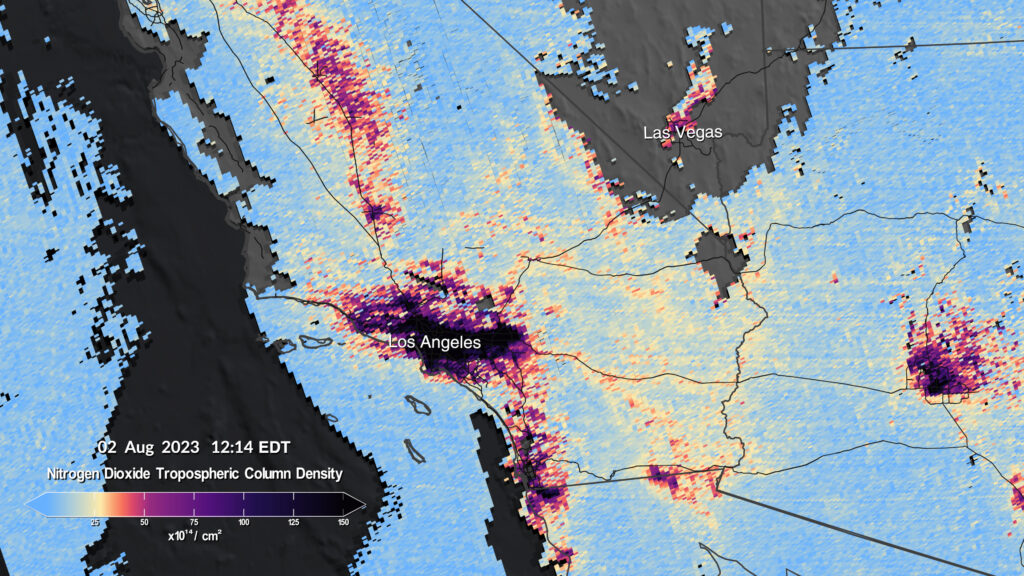
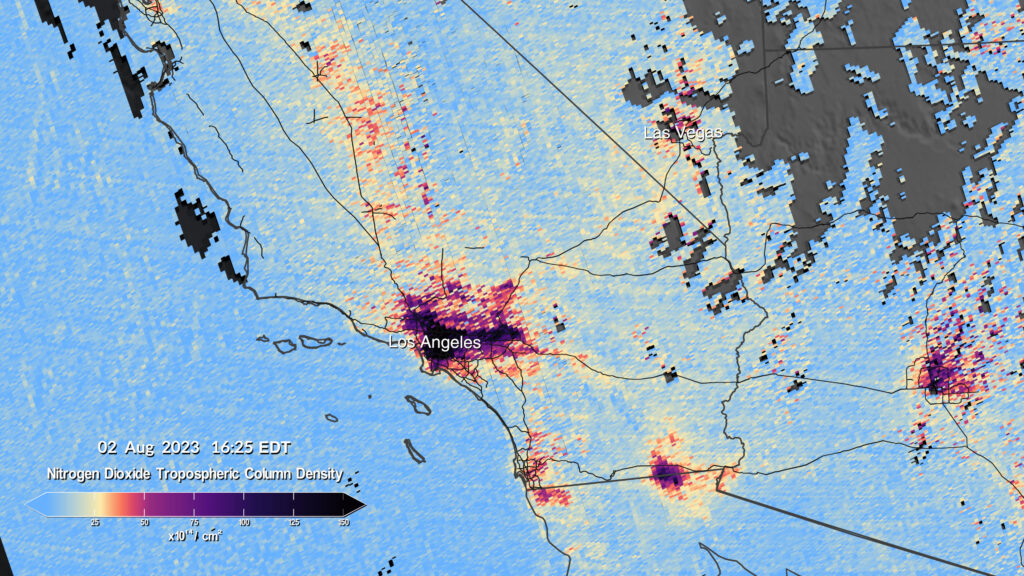
The first pollution maps released by NASA from the mission show concentrations of nitrogen dioxide from pollution around cities and major transportation arteries of North America. TEMPO measures sunlight reflected and scattered off Earth’s surface, clouds and atmosphere. Gases in the atmosphere absorb the sunlight, and the resulting spectra are used to determine the concentrations of several gases in the air, including nitrogen dioxide.

The instrument will begin full operations in October, collecting hourly daytime scans, the first instrument to observe pollution over North America in this way.

TEMPO is part of NASA’s Earth Venture-Instrument program, which includes small, targeted science investigations designed to complement NASA’s larger research missions. The instrument also forms part of a virtual constellation of air pollution monitors for the Northern Hemisphere that also includes South Korea’s Geostationary Environment Monitoring Spectrometer and the European Space Agency’s Sentinel-4 satellite.

Click here for more about TEMPO.

Previous ArticleWhite Nile River flood forecasts for conflict-affected zones
Next Article Francisco Partners to acquire The Weather Company assets from IBM

Read Similar Stories

Space Weather

Northumbria University secures £4m to study Earth’s radiation belts

April 16, 20262 Mins Read
Extreme Weather

AI model improves real-time prediction of wildfire spread

April 16, 20263 Mins Read
Satellites

AI tool uses weather satellite data to map ocean currents in near real time

April 14, 20263 Mins Read
Latest News

Atmospheric G2 secures Japan weather forecasting license

April 21, 2026

China completes Antarctic meteorological research mission with Xuelong icebreaker

April 21, 2026

EWR Radar Systems wins US Air Force contract for portable Doppler radar support

April 20, 2026

Receive breaking stories and features in your inbox each week, for free


Enter your email address:


Supplier Spotlights
  • ZOGLAB Microsystem Co., Ltd
Getting in Touch
  • Contact Us / Advertise
  • Meet the Editors
  • Media Pack
  • Free Weekly E-Newsletter
Our Social Channels
  • Facebook
  • LinkedIn
© 2026 UKi Media & Events a division of UKIP Media & Events Ltd
  • Cookie Policy
  • Privacy Policy
  • Terms and Conditions
  • Notice and Takedown Policy

Type above and press Enter to search. Press Esc to cancel.